
SENECA LAKE
A view form the western shore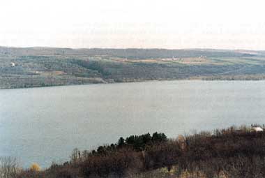
Photo: C. Rossano
A. LOCATION
New York, USA. 42:2 N, 76:6 W; 135.6 m above sea level.B. DESCRIPTION
Seneca Lake is one of a group of long and narrow lakes located in western New York State known as the Finger Lakes. The basins of these north-south oriented lakes were formed by the advance of ice masses during the Ice Ages, and further sculpted by glacial meltwater during the interglacial and postglacial periods. Seneca Lake is 56.6 km long, has a mean width of 3.10 km, and a mean depth of 88.6 m. Seneca Lake is by far the deepest of the Finger Lakes (198.4 m); with the lake floor extending more than 60 meters below sea level. As a result, Seneca Lake's volume is by far the greatest (15.539 km3); and retention time longest (18.1 yr) of the Finger Lakes.Although the Finger Lakes region is now well-known for its many vineyards and orchards, it had been densely forested up until the early 1800's when large areas were cleared for agriculture by white settlers. The forests are now in the process of expanding as marginal farmland is abandoned and gradually invaded by trees.
Of Seneca Lake's 1,180 km2 drainage basin, approximately 40% is forested, 40% is actively farmed, and 3% is residential. Approximately 70,000 people were residing in the drainage basin in 1970.
The climate of the Finger Lakes region is characterized by cold, snowy winters and warm, dry summers; and occasionally the lake freezes over in January or February. However, because the water in the lake acts as a heat-regulator, and because the land surrounding the lake is steeply sloped, Seneca Lake actually has a considerable effect on the local climate. These factors interact to moderate the seasonal temperature extremes and variability within the lake valley. Consequently, the slopes surrounding the lake are ideally suited for growing fruit (1).
C. PHYSICAL DIMENSIONS (1)
| Surface area [km2] | 175 |
| Volume [km3] | 15.5 |
| Maximum depth [m] | 198.4 |
| Mean depth [m] | 88.6 |
| Residence time [yr] | 18.1 |
| Catchment area [km2] | 1,831 |
D. PHYSIOGRAPHIC FEATURES
D1 GEOGRAPHICAL (1) Bathymetric map: Fig. NAM-16-0l. Names of main island: None. Number of outflowing rivers and channels (name): 1.D2 CLIMATIC Climatic data at Geneva, 1933-1962 (2)
| Mean temp. [deg C] | ||||||||||||
|---|---|---|---|---|---|---|---|---|---|---|---|---|
|
Jan
|
Feb | Mar | Apr | May | Jun | Jul | Aug | Sep | Oct | Nov | Dec | Ann. |
| -3.3 | -3.3 | 1.1 | 7.8 | 14.4 | 19.2 | 22.2 | 21.1 | 17.2 | 11.1 | 5.0 | -1.7 | 9.2 |
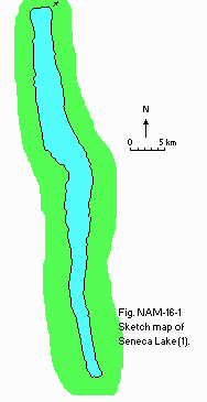
Bathymetric map (1).
Solar radiation: Fig. NAM-16-02.
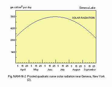
Pooled quadratic curve for solar radiation near Geneva, New York (2).
Water temperature [deg C](1) 1973
| Depth[m] | Jan | Feb | May | Apr | May | Jun | Jul | Aug | Sep | Oct | Nov | Dec |
|---|---|---|---|---|---|---|---|---|---|---|---|---|
| S*1 | - | - | - | 5.6 | - | - | 23.5 | 23.5 | - | - | - | - |
| B*2 | - | - | - | 4.0 | - | - | 4.0 | 5.5 | - | - | - | - |
E. LAKE WATER QUALITY (1)
E1 TRANSPARENCY [m] 1973: 3.6*. * Summer Secchi disc transparency.E6 CHLOROPHYLL CONCENTRATION [micro g l-1]: Fig. NAM-16-03.
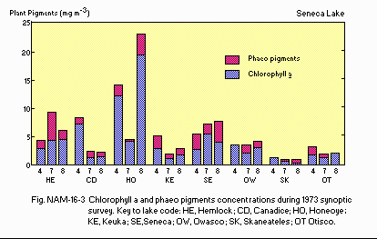
Chlorophyll a and phaeopigments concentrations during the 1973 synoptic survey.
F. BIOLOGICAL FEATURES (1)
F1 FLORA Submerged macrophytes Myriophyllum spicatum, Heteranthera dubia, Potamogeton crispus, P. perfoliatus, Chara sp. Phytoplankton Ankistrodesmus falcatus, Golenkinia radiata, Oocystis lacustris, Scenedesmus armartus, Ceratium hirundinella, Glenodinium borgei, Cryptomonas erosa, Cladomonas fruticulosa, Mallomonas akrokomas.F2 FAUNA Zooplankton Diaptomus minutus, D. oregonenis, Cyclops bicuspidatus, Bosmina longirostris, Ceriodaphnia quadrangula, Mysis relicta, Asplanchna priodonta, Synchaeta stylata. Benthos Pontoporeia hoyi, Chiromomus, Tanypus, Palpomyia, Protenthes, Sphaerium. Fish Alosa pseudoharengus, Salmo gairdneri, Salvelinus namaycush, Cyprinus carpio, Catostomus commersoni, Ictalurus nebulosus, Esox lucius, Hypentelium nigricans, Ambloplites rupestris.
F4 BIOMASS: Fig. NAM-16-04.
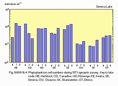
Phytoplankton cell numbers during the 1973 synoptic survey.
G. SOCIO-ECONOMIC CONDITIONS (1)
G1 LAND USE IN THE CATCHMENT AREA| Area [km2] | [%] | |
|---|---|---|
| Natural landscape | ||
| Forest | 476.5 | 40 |
| Agricultural land | ||
| Active agriculture | 501.5 | 43 |
| Inactive agriculture | 165.5 | 14 |
| Residential area | 37.1 | 3 |
| Total | 1,180.6 | 100 |
G3 POPULATION IN THE CATCHMENT AREA
| Total no. Increase | Population density | ||
|---|---|---|---|
| 1930 | 1970 | [%] | [km-2] |
| 44,561 | 69,559 | 56 | 58.9 |
I. DETERIORATION OF LAKE ENVIRONMENTS AND HAZARDS
I3 EUTROPHICATION Nitrogen and phosphorus loadings to the lake [g m-2 yr-1](4) T-P: 0.64.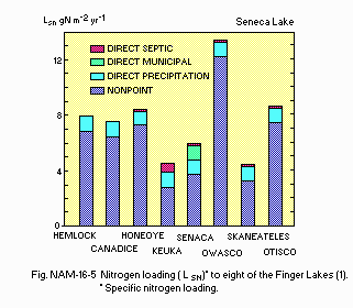
(1) Nitrogen loadings (LSN) to eight of the Finger Lakes.
J. WASTEWATER TREATMENTS (1)
J3 SANITARY FACILITIES AND SEWERAGE Discharge of the City of Geneva's primary sewage treatment plant ca. 7,600 day-1.N. SOURCES OF DATA
- Schaffner, W. R. & Oglesby, R. T. (1978) Limnology of eight Finger Lakes: Hemlock, Canadice, Honeoye, Keuka, Seneca, Owasco, Skaneateles, and Otisco. "Lakes of New York State 1, Ecology of the Finger Lakes" (ed. Bloomfield, J. A.), pp. 313-470. Academic Press, New York, San Francisco, London.
- Stephen, W. E. & Larry, P. K. (1978) The Limnology of Canandaigua Lake. Ibid. pp. 225-311.
- Court, A (1974) The climate of the conterminous United States. "World Surveys of Climatology, Volume 11, Climates of North America" (ed. Bryson, R. A. & Hare, F. K.), p. 312. Elsevier Scientific Publishing Company, Amsterdam-London-New York.
- Oglesby, R. T. & Schaffner, W. R. (1975) The response of lakes to phosphorus. "Nitrogen and Phosphorus Food Production, Waste and the Environment" (ed. Porter, K. S.), Chapter 2, pp. 25-57. Ann Arbor Sci. Publ., Ann Arbor, Michigan.
