
KEUKA LAKE
A view of the nothern shore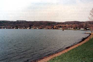
Photo: C. Rossano
A. LOCATION
New York, USA. 42:9 N, 77:4 W; 217.9 m above sea level.B. DESCRIPTION
Keuka Lake is one of a group of long and narrow lakes located in western New York State known as the Finger Lakes. The basins of these north-south oriented lakes were formed by the advance of ice masses during the Ice Ages, and further sculpted by glacial meltwater during the interglacial and postglacial periods. The lake is unique among the Finger Lakes in that it is shaped somewhat like a tuning-fork instead of a cylinder. However, it maintains the typical long, narrow and deep proportions with a length of 31.6 km, mean width of 1.15 km, mean depth of 30.5 m, and a very steep mean slope of 7.8%.Although the Finger Lakes region is now well-known for its many vineyards and orchards, it had been densely forested up until the early 1800's when large areas were cleared for agriculture by white settlers. The forests are now in the process of expanding as marginal farmland is abandoned and gradually invaded by trees. Of Keuka Lake's 405 km2 drainage basin, approximately half is still forested, one-third is actively farmed, and 3% is residential.
The climate of Keuka Lake is characterized by cold, snowy winters and warm, dry summers; and the lake regularly freezes over in the winter. During summer, recreation is very active on Keuka Lake. Boating, sport-fishing, swimming and camping are very popular. A number of wineries and other tourist attractions also surround this 47 km2 lake. The lake has ten tributaries, and one outflowing channel which flows into Seneca Lake (1).
C. PHYSICAL DIMENSIONS (1)
| Surface area [km2] | 47 |
| Volume [km3] | 1.4337 |
| Maximum depth [m] | 55.8 |
| Mean depth [m] | 30.5 |
| Residence time [yr] | 6.3 |
| Catchment area [km2] | 484 |
D. PHYSIOGRAPHIC FEATURES
D1 GEOGRAPHICAL (1) Bathymetric map: Fig. NAM-15-0l. Names of main islands: None. Number of outflowing rivers and channels (name): 1. D2 CLIMATIC Climatic data at Geneva, 1933-1962 (2)| Mean temp. [deg C] | ||||||||||||
|---|---|---|---|---|---|---|---|---|---|---|---|---|
| Jan | Feb | Mar | Apr | May | Jun | Jul | Aug | Sep | Oct | Nov | Dec | Ann. |
| -3.3 | -3.3 | 1.1 | 7.8 | 14.4 | 19.2 | 22.2 | 21.1 | 17.2 | 11.1 | 5.0 | -1.7 | 9.2 |
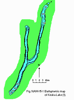
Bathymetric map (1).
Solar radiation: Fig. NAM-15-02.
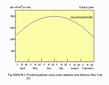
Pooled quadratic curve for solar radiation near Geneva, New York (2).
Water temperature [deg C](1) 1973
| Depth[m] | Jan | Feb | May | Apr | May | Jun | Jul | Aug | Sep | Oct | Nov | Dec |
|---|---|---|---|---|---|---|---|---|---|---|---|---|
| S*1 | - | - | - | 7.6 | - | - | 25.0 | 23.5 | - | - | - | - |
| B*2 | - | - | - | 4.9 | - | - | 6.0 | 5.7 | - | - | - | - |
E. LAKE WATER QUALITY (1)
E1 TRANSPARENCY [m] 1973: 7.0*. * Summer Secchi disk transparency.E6 CHLOROPHYLL CONCENTRATION [micro g l-1]: Fig. NAM-15-03.
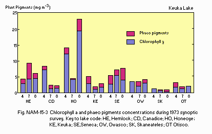
Chlorophyll a and phaeopigments concentrations during the 1973 synoptic survey.
F. BIOLOGICAL FEATURES (1)
F1 FLORA Submerged macrophytes Myriophyllum spicatum, Heteranthera dubia, Najas flexilis, Potamogeton crispus, Nitella sp., Chara sp., Vallisneria americana. Phytoplankton Ankistrodesmus falcatus, Scenedesmus bijuga, Ceratium hirundinella, Peridinium cinctum, Cryptomonas erosa, Cladomonus fruticulosa, Dinobryon sociale, Melosira granulata, Asterionella formosa, Fragilaria crotonensis.F2 FAUNA Zooplankton Cyolops bicuspidatus, Mesocyclops edax, Daphnia dubia, D. parvula, Leptodora kindtii, Difflugia lebes, Chonochilus unicornis, Keratella cochlearis, Polyarthra euryptera, Trichocerca multicrinis. Benthos Pontoporeia hoyi, Chironomus, Tanypus, Palpomyia, Protenthes, Sphaerium. Fish Alosa pseudoharengus, Salvelinus namaycush, Osmerus mordax, Notemigonus chrysoleucas, Catostomus commersoni, Ambloplites rupestris, Lepomis macrochirus, Micropterus dolomieu, M. salmoides, Perca flavescens.
F4 BIOMASS: Fig. NAM-15-04.
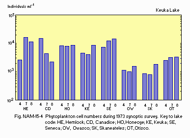
Phytoplankton cell numbers during the 1973 synoptic survey.
G. SOCIO-ECONOMIC CONDITIONS (1)
G1 LAND USE IN THE CATCHMENT AREA| Area [km2] | [%] | |
|---|---|---|
| Natural landscape | ||
| Forest | 198.9 | 49 |
| Agricultural land | ||
| Active agriculture | 132.2 | 33 |
| Inactive agriculture | 59.7 | 15 |
| Residential area | 13.8 | 3 |
| Total | 404.6 | 100 |
| Total | Increase | Population density | |
|---|---|---|---|
| 1930 | 1970 | [%] | [km-2] |
| 9,500 | 12,125 | 28 | 30.0 |
I. DETERIORATION OF LAKE ENVIRONMENTS AND HAZARDS
I3 EUTROPHICATION Nitrogen and phosphorus loadings to the lake [g m-2 yr-1](4) T-P: 0.45.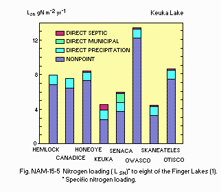
(1) Nitrogen loadings (LSN) to eight of the Finger Lakes.
N. SOURCES OF DATA
- Schaffner, W. R. & Oglesby, R. T. (1978) Limnology of eight Finger Lakes: Hemlock, Canadice, Honeoye, Keuka, Seneca, Owasco, Skaneateles, and Otisce. "Lakes of New York State 1, Ecology of the Finger Lakes" (ed. Bloomfield, J. A.), pp. 313-470. Academic Press, New York, San Francisco, London.
- Stephen, W. E. & Larry, P. K. (1978) The limnology of Canandaigua Lake. Ibid. pp. 225-311.
- Court, A (1974) The Climate of the Conterminous United States. "World Surveys of Climatology Volume 11, Climates of North America" (ed. Bryson, R. A. & Hare, F. K.), p. 312. Elsevier Scientific Publishing Company Amsterdam-London-New York.
- Oglesby, R. T. & Schaffner, W. R. (1975) The response of lakes to phosphorus. "Nitrogen and Phosphorus Food Production, Waste and the Environment" (ed. Porter, K. S.), Chapter 2, pp. 25-57. Ann Arbor Sci. Publ., Ann Arbor, Michigan.
