
CANANDAIGUA LAKE
A view from the northwen and at Canadaigum City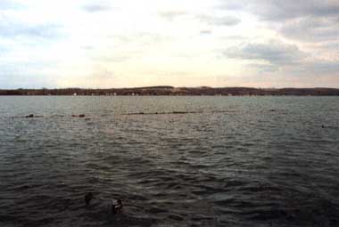
Photo: C. Rossano
A. LOCATION
New York, USA. 42:6 N, 77:8 W; 209.6 m above sea level.B. DESCRIPTION
Canandaigua Lake is one of a group of long and narrow lakes located in western New York State known as the Finger Lakes. The basins of these north-south oriented lakes were formed by the advance of ice masses during the Ice Ages, and further sculpted by glacial meltwater during the interglacial and postglacial periods.Although the Finger Lakes region is now well-known for its many vineyards and orchards, it had been densely forested up until the early 1800's when large areas were cleared for agriculture by white settlers. The forests are now in the process of expanding as marginal farmland is abandoned and gradually invaded by trees. Of Canandaigua Lake's 400 km2 drainage basin, approximately half is still forested, 40% is in active agriculture, 2% is residential, and less than 1% is industrial. Active agriculture is confined mainly to the northern areas, while the southern areas are heavily forested. The climate of Canandaigua Lake is characterized by long, cold winters and warm, dry summers. Most winters, the north and south ends of the lake freeze over for about a kilometer or two from their ends. Occasionally, the entire lake freezes over. The lake is utilized primarily as a water source for five municipalities in the area and the residents around the lake perimeter. Secondarily, it is used for recreation, flow equalization, and, to a limited extent, power. There are several public recreation areas around the lake which provide for summer swimming, boating and fishing. The level of the lake is regulated within the narrow range between 209.4 and 210 m MSL (1).
C. PHYSICAL DIMENSIONS (1)
| Surface area [km2] | 42 |
| Volume [km3] | 1.6401 |
| Maximum depth [m] | 84.1 |
| Mean depth [m] | 38.8 |
| Water level | Regulated |
| Length of shoreline [km] | 57.8 |
| Residence time [yr] | 13.4 |
| Catchment area [km2] | 407 |
D. PHYSIOGRAPHIC FEATURES
D1 GEOGRAPHICAL (1) Bathymetric map: Fig. NAM-14-0l. Names of main islands: Squaw. Number of outflowing rivers and channels (name): 1 (Canandaigua Outlet). D2 CLIMATIC Climatic data at Geneva, 1933-1962 (1)| Mean temp. [deg C] | ||||||||||||
|---|---|---|---|---|---|---|---|---|---|---|---|---|
|
Jan
|
Feb | Mar | Apr | May | Jun | Jul | Aug | Sep | Oct | Nov | Dec | Ann. |
| -3.3 | -3.3 | 1.1 | 7.8 | 14.4 | 19.2 | 22.2 | 21.1 | 17.2 | 11.1 | 5.0 | -1.7 | 9.2 |
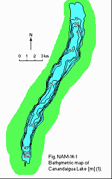
Bathymetric map [m](1).
Solar radiation: Fig. NAM-14-02.
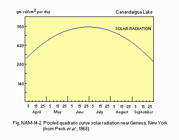
Pooled quadratic curve for solar radiation near Geneva, New York (2).
Water temperature: Fig. NAM-14-03.
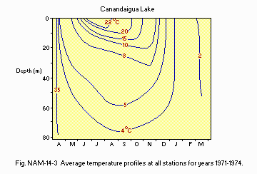
Average temperature profiles at all stations for years 1971-1974 (1).
Freezing period: Usually January-March. Mixing type: Dimictic (1).
E. LAKE WATER QUALITY (1)
E1 TRANSPARENCY [m]: Fig. NAM-14-04.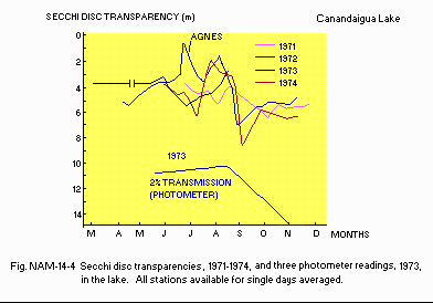
Secchi disc transparencies, 1971-1974, and three photometer readings, 1973, in the lake.
E2 pH: Fig. NAM-14-05.
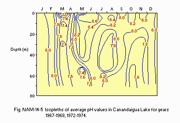
Isopleths of average pH values in Canandaigua Lake for years 1967-1968, 1972- 1974.
E4 DO [mg l-1]: Fig. NAM-14-06.
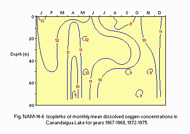
Isopleths of monthly mean dissolved oxygen concentrations in Canandaigua Lake for years 1967-1968, 1972-1975.
E6 CHLOROPHYLL CONCENTRATION [micro g l-1] 1973
| Depth[m] | Jan | Feb | Mar | Apr | May | Jun | Jul | Aug | Sep | Oct | Nov | Dec |
|---|---|---|---|---|---|---|---|---|---|---|---|---|
| 0 | - | - | - | 2.2 | - | - | 2.1 | 0.7 | - | - | - | - |
| 5 | - | - | - | 2.5 | - | - | 2.7 | 1.5 | - | - | - | - |
| 10 | - | - | - | 2.5 | - | - | 3.5 | 1.3 | - | - | - | - |
| 50-65 | - | - | - | 1.6 | - | - | 1.1 | 0.7 | - | - | - | - |
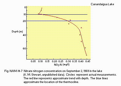
Nitrate nitrogen concentration on September 2, 1969 in the lake (K.M. Stewart, unpublished data).
E8 PHOSPHORUS CONCENTRATION PO4-P [mg l-1] Mean of 3 stations, 1972
| Depth | Jan | Feb | Mar | Apr | May | Jun | Jul | Aug | Sep | Oct | Nov | Dec |
|---|---|---|---|---|---|---|---|---|---|---|---|---|
| 0 | - | - | - | - | .004 | .009 | - | - | - | .006 | - | - |
| 1-5 | - | - | - | - | .006 | .009 | - | - | - | .004 | - | - |
| 6-10 | - | - | - | - | .007 | - | - | - | - | .006 | - | - |
| 11-20 | - | - | - | - | - | - | - | - | - | - | - | - |
| 21-30 | - | - | - | - | - | .009 | - | - | - | .005 | - | - |
| 31-40 | - | - | - | - | - | .009 | - | - | - | .006 | - | - |
| 41-50 | - | - | - | - | - | - | - | - | - | .005 | - | - |
| 51-60 | - | - | - | - | - | .010 | - | - | - | .007 | - | - |
| Depth[m] | Jan | Feb | Mar | Apr | May | Jun | Jul | Aug | Sep | Oct | Nov | Dec |
|---|---|---|---|---|---|---|---|---|---|---|---|---|
| 0 | - | - | - | - | .008 | - | .014 | - | - | .007 | - | - |
| 1- 5 | - | - | - | - | .009 | - | .032 | - | - | .008 | - | - |
| 6-10 | - | - | - | - | .011 | - | - | - | - | .007 | - | - |
| 11-20 | - | - | - | - | - | - | - | - | - | .007 | - | - |
| 21-30 | - | - | - | - | - | - | .015 | - | - | .006 | - | - |
| 31-40 | - | - | - | - | - | - | .031 | - | - | .007 | - | - |
| 41-50 | - | - | - | - | - | - | - | - | - | .009 | - | - |
| 51-60 | - | - | - | - | - | - | .029 | - | - | .029 | - | - |
F. BIOLOGICAL FEATURES (1)
F1 FLORA Submerged macrophytes Ceratophyllum demersum, Anacharis canadensis, Myriophyllum exlabescens, Najas flexilis, Ranunculus longirostris, Potamogeton crispus, P. gramineus. Phytoplankton Ankistrodesmus convolutus, Gloeocystis ampla, Tetraedron minimum, Dinobryon bavaricum, Monocilia flavescens, Rhizpsolenia gracilis, Tabellaria fenestrata, Meridion circulare, Fragilaria virescens, Gymnodinium caudatum, Chroococus limneticus, Oscillatoria prolifica.F2 FAUNA Zooplankton Mysis relicta, Diaptomus sicilis, Limnocalanus macrurus, Pontoporeia affinis, Keratella cochlearis, Asplanchna priodonta, Ceriodaphnia pulchella, Diaphanosoma leuchtenbergianum, Daphnia retrocurva, Leptodora kindtii, Polyphemus pediculus. Benthos Hexagenia sp., Heptagenia sp., Sialis sp., Odonata spp., Helisoma anceps, Physa sayii, Goniobasis livescens, Amnicola limnosa, Valvata tricarinata, Pontoporeia affinis. Fish Micropterus salmoides, Ambloplites rupestris, Pimephales notatus, Alosa pseudoharengus, Salmo trutta, Salvelinus namaycush.
F4 BIOMASS: Fig. NAM-14-08.
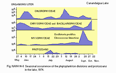
Seasonal occurrence of the phytoplankton divisions and protozoans in the lake, 1974.
G. SOCIO-ECONOMIC CONDITIONS (1)
G1 LAND USE IN THE CATCHMENT AREA 1971| Area [km2] | [%] | |
|---|---|---|
| Natural landscape | ||
| Forest | 202.25 | 49.7 |
| Agricultural land | ||
| Active agriculture | 158.17 | 38.8 |
| Inactive agriculture | 35.89 | 8.8 |
| Residential area | 6.96 | 1.7 |
| Others | ||
| Commercial | 0.60 | 0.1 |
| Industrial | 0.20 | 0.1 |
| Outdoor recreation | 1.74 | 0.4 |
| Extractive | 0.60 | 0.1 |
| Public | 0.67 | 0.2 |
| Total | 407.23 | 100 |
G3 POPULATION IN THE CATCHMENT AREA 1970
| Population | Major cities | ||
|---|---|---|---|
| Population | density [km-2] | (population) | |
| Total | ca. 7,700 | 19.0 | Canandaigua |
H. LAKE UTILIZATION (1)
H1 LAKE UTILIZATION Recreation (swimming, boating, picnic, hunting, fishing), power (to a limited extent), water supply and, flow equalization.I. DETERIORATION OF LAKE ENVIRONMENTS AND HAZARDS (1)
I3 EUTROPHICATION Nitrogen and phosphorus loadings to the lake [t yr-1] 1972, 1973| Sources | Total |
|---|---|
| T-N | 158.9 |
| T-P | 6.0 |
J. WASTEWATER TREATMENTS (1)
J3 SANITARY FACILITIES AND SEWERAGE Municipal wastewater treatment systems: Sand filters, septic tanks. Industrial wastewater treatment systems: Rotary screen, lagoons.N. SOURCES OF DATA
- Eaton, S. W. & Kardos, L. P. (1978) The limnology of Canandaigua Lake. "Lakes of New York State 1, Ecology of the Finger Lakes" (ed. Bloomfield, J. A.), pp. 225-311. Academic Press, New York.
- Peck, N. H., Vittum, M. T., & Gibbs, G. H. (1968) N. Y. State Agric. Exp. Stn., Cornell University, Bull. 822, 3-26.
