
HONEOYE LAKE
A view from the northern shore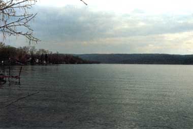
Photo: C.Rossano
A. LOCATION
- New York, USA.
- 42:7N, 77:1W; 245.0 m above sea level.
B. DESCRIPTION
Honeoye Lake is one of a group of long and narrow lakes located in western New York State known as the Finger Lakes. The basins of these north-south oriented lakes were formed by the advance of ice masses during the Ice Ages, and further sculpted by glacial meltwater during the interglacial and postglacial periods. Although the lake posesses the long and narrow shape characteristic of the Finger Lakes, it is by far the shallowest (4.9 m) of the group. In addition, it is comparatively small (7.05 km2), has the shortest retention time (0.8 yr) and is generally the warmest. As might be expected from this description, Honeoye Lake is considered one of the most eutrophic of the Finger Lakes. Although the Finger Lakes region is now well-known for its many vineyards and orchards, it had been densely forested up until the early 1800's when large areas were cleared for agriculture by white settlers. The forests are now in the process of expanding as marginal farmland is abandoned and gradually invaded by trees.Of Honeoye Lake's 95 km2 drainage basin, approximately
85% is forested (the highest proportion among the Finger Lakes), 10% is
actively farmed, and 2% is residential. The lake is used extensively for
recreation, including swimming, boating and fishing. Lakefront property
is privately owned, and highly developed. As a result, water quality has
suffered from failing septic systems, oil from power boats, and other causes.
The climate of Honeoye Lake is characterized by cold, snowy winters and
warm, dry summers; and the lake regularly freezes over in the winter.
C. PHYSICAL DIMENSIONS (1)
| Surface area [km2] | 7 |
| Volume [km3] | 0.03481 |
| Maximum depth [m] | 9.2 |
| Mean depth [m] | 4.9 |
| Residence time [yr] | 0.8 |
| Catchment area [km2] | 95 |
D. PHYSIOGRAPHIC FEATURES
D1 GEOGRAPHICAL (1)
- Bathymetric map: Fig. NAM-13-0l.
- Names of main islands: None.
- Number of outflowing rivers and channels (name): 1.
D2 CLIMATIC
- Climatic data at Hemlock, 1969-1974 (2)
| Jan | Feb | Mar | Apr | May | Jun | Jul | Aug | Sep | Oct | Nov | Dec | Ann. | |
|---|---|---|---|---|---|---|---|---|---|---|---|---|---|
| Mean temp. [deg C] | - | -5.4 | - | - | - | - | 21 | - | - | - | - | - | 8.19 |
| Precipitation [mm]
(1968-1974) |
594-1,017 (2). | ||||||||||||
- Solar radiation (Genesco, 1975): 1.2*1-25.4*2 MJ m-2 day-1 (2).
*1 January. *2 July.
- Fig. NAM-13-01
Bathymetric map [m](1).

- Water temperature [deg C](1)
| Depth [m] | Jan | Feb | Mar | Apr | May | Jun | Jul | Aug | Sep | Oct | Nov | Dec |
|---|---|---|---|---|---|---|---|---|---|---|---|---|
| S*1 | - | - | - | 12.5 | - | - | 24.0 | 25.0 | - | - | - | - |
| B*2 | - | - | 10.2 | - | - | 22.4 | 22.0 | - | - | - | - | - |
- Mixing type: Monomictic (1).
E. LAKE WATER QUALITY (1)
El TRANSPARENCY [m]- Lake centre, 1973: 3.0*.
* Summer Secchi disc transparency.
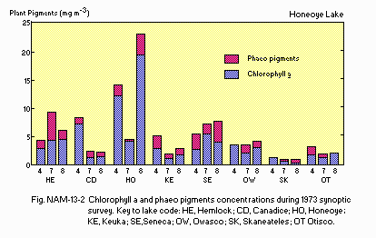
E6 CHLOROPHYLL CONCENTRATION [micro l-1]: Fig. NAM-13-02.
- Fig. NAM-13-02
Chlorophyll a and phaeopigments concentrations during 1973 synoptic survey.
F. BIOLOGICAL FEATURES (1)
F1 FLORA
- Phytoplankton
Scenedesmus bijuga, Ceratium hirundinella, Glenodinium gymnodinium, Peridinium cinctum, Cryptomonas erosa, Dinobryon sertularia, Mallomonas akrokomos, Melosira granulata, Asterionella formosa, Fragilaria crotonensis, Nitzshia acicularis.
F2 FAUNA
- Zooplankton
- Benthos
Cyclops vernalis, Mesocyclops edax, Chydorus sphaericus, Daphnia longiremis, Leptodora kindtii, Difflugia lebes, Conochilus unicornis, Keratella cochlearis, Polyarthra euryptera, Trichocerca longiseta.
Pontoporeia hoyi, Chiromomus, Tanypus, Palpomyia, Protenthes, Sphaerium.
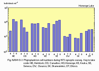
F4 BIOMASS: Fig. NAM-13-03.
- Fig. NAM-13-03
Phytoplankton cell numbers during 1973 synoptic survey.
G. SOCIO-ECONOMIC CONDITIONS (1)
G1 LAND USE IN THE CATCHMENT AREA
| Area [km2] | [%] | |
|---|---|---|
| Natural landscape Forest | 80.7 | 85 |
| Agricultural land | ||
| - Active agriculture | 9.1 | 10 |
| - Inactive agriculture | 3.6 | 4 |
| Residential area | 1.6 | 2 |
| Total | 95.0 | 100 |
- Main types of woody vegetation (main species)
Oak/northern hardwoods (Quercus spp., Carya spp.).
G3 POPULATION IN THE CATCHMENT AREA
| Total no. | Increase [%] | Population density [km-2] | |
|---|---|---|---|
| 1930 | 1970 | ||
| 823 | 1,276 | 55 | 13.4 |
I. DETERIORATION OF LAKE ENVIRONMENTS AND HAZARDS
I3 EUTROPHICATION
- Nitrogen and phosphorus loadings to the lake [g m-2 yr-1](3)
T-P: 0.38.
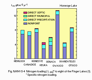
- Fig. NAM-13-04 (1)
Nitrogen loading (LSN)* to eight of the Finger Lakes.
* Specific nitrogen loading.
N. SOURCES OF DATA
- Schaffner, W. R., & Oglesby, R. T. (1978) Limnology of eight Finger Lakes: Hemlock, Canadice, Honeoye, Keuka, Seneca, Owasco, Skaneateles, and Otisco. "Lakes of New York State 1, Ecology of the Finger Lakes" (ed. Bloomfield, J. A.), pp. 313-470. Academic Press, New York, San Francisco, London.
- Forest, H. S., Wade, J. Q. & Maxwell, T. F. (1978) The limnology of Conesus Lake. Ibid. pp. 121-224.
- Oglesby, R. T. & Schaffner, W. R. (1975) The response of lakes to phosphorus. "Nitrogen and Phosphorus Food Production, Waste and the Environment" (ed. Porter, K. S.), Chapter 2, pp. 25-57. Ann Arbor Sci. Publ., Ann Arbor, Michigan.
