
LAKE EYRE
An aerial view of Level Post Baywith Lake Eyre South in the background

Photo: B.Mossel
A. LOCATION
- South Australia, Australia.
- 28:30S, 137:20E; -9.5* m above sea level.
* At 1974 flood level.
B. DESCRIPTION
-
Lake Eyre, a great salt lake of tectonic origin, lies asymmetrically in the south-western corner of the closed inland drainage basin in the heart of the Australian continent. With an area of 1,140,000 km2, Lake Eyre Basin is the largest Australian drainage division apart from the Western Plateau and is one of the largest areas of internal drainage in the world. The lake, whose lowest parts lie 15.2 m below sea level, consists of two sections. Lake Eyre North, 144 km long and 77 km wide, is joined by the narrow Goyder Channel to Lake Eyre South, which is 64 km long and 24 km in width. Not so long ago it was considered to be permanently dry, but the last forty years have witnessed some twenty flood events, with the most spectacular fillings occurring in 1950, 1974 and 1984.
The deepest region of Lake Eyre North is the eastern part of Belt Bay in which bottom levels were found the lowest point on the Australian continent. The floor of the lake is very flat, therefore the definition of the exact location is rather difficult. The shores of the lake are well defined and consist of sand dunes, cliffs of eroded gypseous loam or low rocky escarpments. The south-eastern coastline, which consists of sand cliffs, is being rapidly cut back, with an erosion rate in the order of 5 m per flooding.
Trustworthy data on the filling of Lake Eyre South are reported for the floodings of 1938, 1955, 1963, 1968, 1973, 1974, 1975, 1976 and 1984. In 1984 Lake Eyre South overflowed to Lake Eyre North. In 1974 water flowed from Lake Eyre North to Lake Eyre South between March and October when an equilibrium level was obtained. Large quantities of salt, estimated at 30 million tons (7.5% of Lake Eyre North content), were transferred into Lake Eyre South during this event, creating, in its lowest portion, a salt crust up to 290 mm thick for the first time on record.
The vast catchment areas of the lakes are only marginally desert and as such are very responsive to even slight variations of rainfall. Considering the long term trends of climatic change is therefore essential. Almost all the non-desert parts of the Lake Eyre Basin area are used for low-intensity grazing of sheep for wool and beef cattle. The very variable rainfall is the most important factor for provision of feed, and low rainfall seasons determine stocking rates. Grazing capacity is directly related to the distribution of artesian wells and excavated tanks. The area of irrigated agriculture is insignificant and restricted to pasture on lands bordering other divisions (l).
C. PHYSICAL DIMENSIONS (Q, 1)
| Basin | North | South | Total |
|---|---|---|---|
| Surface area [km2] | 8,430 | 1,260 | 9,690 |
| Volume [km3] | 27.7 | 2.4 | 30.1 |
| Maximum depth [m] | 5.7 | 3.7 | - |
| Mean depth [m] | 3.3 | 1.9 | - |
| Water level | Unregulated | ||
| Normal range of annual water level fluctuation [m] | - | - | 2 |
| Length of shoreline [km] | 1,390 | 328 | 1,718 |
| Catchment area [km2] | - | - | 1,140,000 |
D. PHYSIOGRAPHIC FEATURES
D1 GEOGRAPHICAL- Sketch map: Fig. OCE-04-01.
- Bathymetric map: Fig. OCE-04-02.
- Names of main islands: Brooks and Dulhunty.
- Number of outflowing rivers and channels (name): None.
- Climatic data at Oodnadatta, 1920-1970
| Jan | Feb | Mar | Apr | May | Jun | Jul | Aug | Sep | Oct | Nov | Dec | Ann. | |
|---|---|---|---|---|---|---|---|---|---|---|---|---|---|
| Mean temp. [deg C] | 29.3 | 28.3 | 26.2 | 20.5 | 26.0 | 12.7 | 12.4 | 14.2 | 18.7 | 22.1 | 25.5 | 28.7 | 21.2 |
| Precipitation [mm] | 18 | 34 | 18 | 6 | 16 | 10 | 12 | 10 | 7 | 12 | 8 | 15 | 167 |
- Number of hours of bright sunshine: 3,410 hr yr-1.
- Solar radiation (Alice Springs, 1920-1970): 21.8 MJ m-2 day-1.
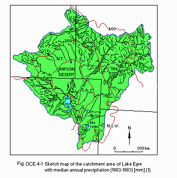
Sketch map of the catchment area with median annual precipitation (1883- 1983)[mm](1).
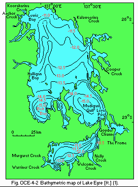
Bathymetric map (1).
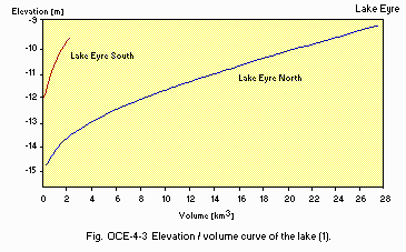
Elevation/volume curve of the lake (1).
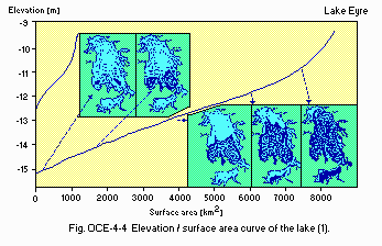
Elevation/surface area curve of the lake (1).
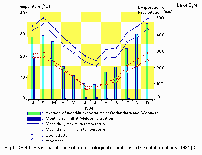
Seasonal change of meteorological conditions in the catchment area, 1984.
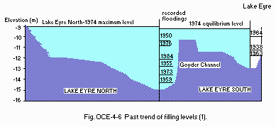
Past trend of filling levels (1).
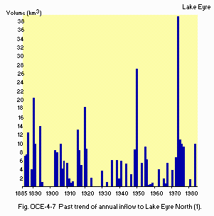
Past trend of annual inflow to Lake Eyre North (1).
- Water temperature [deg C](1) (1974-1983)
| Min | Max | Ann. | |
|---|---|---|---|
| Cooper Creek*1 | 13.0 | 21.0 | 22.6 |
| Diamantina R.*2 | 30.0 | 33.0 | 24.8 |
- Mixing type: None
E. LAKE WATER QUALITY
E2 pH (1)| July 1978 and 1983 | |||
| Min | Max | Ann. | |
|---|---|---|---|
| Cooper Creek*1 | 7.1 | 8.7 | 7.8 |
| Diamantina R.*2 | 7.5 | 7.9 | 7.7 |
| July 1978 and June 1983 | |||
| Min | Max | Ann. | |
|---|---|---|---|
| Cooper Creek*1 | 19 | 140 | 50 |
| Diamantina R.*2 | 244 | 684 | 442 |
| 1980 and 1983 | |||
| Min | Max | Ann. | |
|---|---|---|---|
| Cooper Creek*1 | 5.8 | 10.8 | 8.2 |
| Diamantina R.*2 | 6.4 | 8.3 | 7.2 |
- NH4-N [mg l-1]
| July 1978 and June 1983 | |||
| Min | Max | Ann. | |
|---|---|---|---|
| Cooper Creek*1 | 0.07 | 0.07 | 0.07 |
| Diamantina R.*2 | 0.04 | 0.52 | 0.19 |
- NO3-N [mg l-1]
| July 1978 and June 1983 | |||
| Min | Max | Ann. | |
|---|---|---|---|
| Cooper Creek*1 | 0.01 | 0.57 | 0.20 |
| Diamantina R.*2 | 0.10 | 0.26 | 0.18 |
- Total-N [mg l-1]
| July 1978 and June 1983 | |||
| Min | Max | Ann. | |
|---|---|---|---|
| Cooper Creek*1 | 0.72 | 1.12 | 0.93 |
| Diamantina R.*2 | 0.71 | 1.20 | 1.01 |
- PO4-P [mg l-1]
| July 1978 and June 1983 | |||
| Min | Max | Ann. | |
|---|---|---|---|
| Cooper Creek*1 | 0.12 | 0.34 | 0.20 |
| Diamantina R.*2 | 0.15 | 0.21 | 0.20 |
- Total-P [mg l-1](1)
| July 1978 and June 1983 | |||
| Min | Max | Ann. | |
|---|---|---|---|
| Cooper Creek*1 | 0.25 | 0.91 | 0.42 |
| Diamantina R.*2 | 0.25 | 0.81 | 0.60 |
| Date | Salinity | Na | K | Ca | Mg | Cl | SO4 | HCO3 | CO3 |
|---|---|---|---|---|---|---|---|---|---|
| 14 Feb | 25,331 | 9,114 | <1 | 545 | 53 | 14,290 | 1,274 | 55 | 0 |
| 28 Mar | 40,989 | 14,620 | 70 | 876 | 150 | 23,000 | 2,140 | 35 | 7 |
| 30 Mar | 42,355 | 15,150 | 93 | 887 | 143 | 23,350 | 2,700 | 32 | 0 |
| 30 Apr | 49,023 | 17,520 | 70 | 1,050 | 171 | 27,220 | 2,950 | 42 | 0 |
| 7 May | 51,301 | 18,400 | 46 | 1,040 | 187 | 28,300 | 3,280 | 48 | 0 |
| 28 May | 57,728 | 20,640 | 48 | 1,240 | 193 | 31,880 | 3,670 | 57 | 0 |
| 25 Jun | 61,278 | 21,970 | 49 | 1,350 | 173 | 34,360 | 3,310 | 66 | 0 |
| 21 Jul | 64,969 | 23,230 | 92 | 1,350 | 236 | 35,910 | 4,070 | 81 | 0 |
| 27 Aug | 71,248 | 25,500 | 136 | 1,450 | 264 | 39,640 | 4,170 | 88 | 0 |
| 24 Sep | 86,710 | 31,200 | 68 | 1,680 | 310 | 48,100 | 5,290 | 62 | 0 |
| 28 Oct | 117,797 | 42,600 | 111 | 2,050 | 451 | 65,700 | 6,820 | 65 | 0 |
| 30 Oct | 120,067 | 43,800 | 111 | 1,820 | 473 | 67,500 | 6,300 | 63 | 0 |
| 26 Nov | 162,697 | 60,300 | 129 | 1,650 | 725 | 93,100 | 6,720 | 73 | 0 |
| 17 Dec | 217,350 | 82,000 | 208 | 1,220 | 874 | 126,200 | 6,800 | 48 | 0 |
| 16 Jan* | 272,819 | 101,300 | 555 | 459 | 2,500 | 155,600 | 12,300 | 105 | 0 |
F. BIOLOGICAL FEATURES
F1 FLORA (4)- Emerged macrophytes
Cyperus gymnocaulos, Typha domingensis, Phragmites australis. - Submerged macrophytes
Potamogeton sp., Halosarcia spp., Sclerostegia spp., Eriocaulon carsonii, Gahnia trifida, Machaerina juncea.
- Zooplankton (3)
Brachionus plicatilis, Parartemia minuta, Moina baylyi, Daphniopsis sp., Microcyclops platypus, Microcyclops sp. - Benthos (3, 4)
Heterocypris sp., Diacypris sp., Trigonocypris glabulosa, Reticypris kurdimurka, Mytilocypris splendida, Ngarawa dirga, Phreatomerus latipes, Afrochiltonia spp., Paracylops sp. - Fish (3, 4)
Chlamydogobius eremius, Neosilurus sp., Craterocephalus dalhousiensis, C. eyresii, Gambusia affinis, Cherax destructor, Caridina thermophila.
G. SOCIO-ECONOMIC CONDITIONS
G1 LAND USE IN THE CATCHMENT AREA (1) (1986)- Types of important landscape: Scattered pasture and sandhill desert.
- Types of important natural vegetation: None.
- Main kinds of crops: Grass.
- Levels of fertilizer application on crop fields: Low.
| No. of establishments | |
|---|---|
| Primary industry | |
| - Extensive stock raising | 1,367 |
| Secondary industry | None |
| Tertiary industry | None |
- Numbers of domestic animals in the catchment area
Cattle 1,424,000, sheep 4,390,000.
| Population | Population density [km-2] | Major cities (population) | |
|---|---|---|---|
| Rural | 35,000 | Alice Springs (22,800) | |
| Total | 50,000 | 0.04 |
H. LAKE UTILIZATION
H1 LAKE UTILIZATION (1)- Source of water.
I. DETERIORATION OF LAKE ENVIRONMENTS AND HAZARDS
I1 ENHANCED SILTATION (1)- Extent of damage: Heavy siltation, but no damage.
- Present status: Analyzed, but not detected.
- Water quality standards for freshwater sources (6)
| Item | Limit concentration [mg l-1] | Item | concentration [mg l-1] |
|---|---|---|---|
| As | 0.05 | Pesticides | |
| Ba | 1.0 | - Endrin | 0.001 |
| B | 1.0 | - Chlordane | 0.001 |
| Cd | 0.01 | - Toxaphene | 0.001 |
| Cl | 250 | - Organic phosphates | 0.05 |
| Cr(6+) | 0.05 | - Organic chlorides | 0.01 |
| Cu | 1.0 | - Carbides | 0.1 |
| CN | 0.05 | - Hydrocarbon fluorides | 0.001 |
| F | 1.5 | Herbicides | |
| Fe(filtrable) | 0.3 | - 2,4-D | 0.1 |
| Pb | 0.05 | - 2,4,5-T | 0.1 |
| Mn(filtrable) | 0.05 | - Phenylurea | 0.1 |
| Hg | 0.001 | - Triazine | 0.1 |
| MBAS | 0.5 | - Dipyridyl | 0.1 |
| NH3-N | 0.5 | - Acrolein | 0.1 |
| Phenol | 0.001 |
- Nuisance caused by eutrophication: None.
- Extent of damage: None.
J. WASTEWATER TREATMENTS
J1 GENERATION OF POLLUTANTS IN THE CATCHMENT AREA (1)- (a) Pristine lake environments.
K. IMPROVEMENT WORKS IN THE LAKE (1)
- None.
L. DEVELOPMENT PLANS (1)
- None.
M. LEGISLATIVE AND INSTITUTIONAL MEASURES FOR UPGRADING LAKE ENVIRONMENTS
M1 NATIONAL AND LOCAL LAWS CONCERNED (6)- Names of the laws concerned (the year of legislation)
- Clean Water Act (1970)
- State Pollution Control Commission Act (1970)
- Clean Waters Regulations (1972)
- Responsible authorities (6)
- State Government
- State Pollution Control Commission
N. SOURCES OF DATA
- Data supplied by Dr. V. Kotwicki, and Dr. A. R. Atterton, Engineering and Water Supply Department, State Administration Centre, Adelaide and Dr. D. Corcoran, Australian Embassy, Tokyo.
- Kotwicki, V. (1986) Floods of Lake Eyre. 99 pp. Engineering and Water Supply Department, Adelaide.
- Gentilli, J. (1971) Climatic tables for Australia and New Zealand. "World Survey of Climatology Volume 13, Climates of Australia and New Zealand" (ed. Gentilli, J.), pp. 269-384. Elsevier Scientific Publishing Company, Amsterdam-London-New York.
- Williams, W. D. & Kokkim, M. J. (1988) Hydrobiologia, 158: 227-236.
- Ponder, W. F. (1986) Mound springs of the Great Artesian Basin. "Limnology in Australia" (ed. De Deckker, P. and Williams, W. D.), pp. 403-420. Dr. W. Junk Publishers, Dordrecht/ Boston/Lancaster.
- Corcoran, D. & Kotwicki, V. Personal communication.
- Kanamori, S. (1980) Journal of Water & Waste (Yosui to Haisui), 22: 581 590.*
* Printed in Japanese.
