
LAKE ROTORUA
An aerial view of the whole lake with its central island
Photo: G.R.Fish
A. LOCATION
- South Auckland, New Zealand.
- 38:05S, 176:15E; 280 m above sea level.
B. DESCRIPTION
-
The lake basin originated in a caldera about 100,000 years ago. Further volcanic activity changed the shape and drainage from the basin. The present lake size and outflow were established about 13,000 years ago but geothermal activity is still evident near the lake which receives hot water inflows from several springs and geysers near its southern shore, some of which carry white colloidal silica.
The lake has become highly eutrophic in recent years. The source of about half its N and P income is from the inflow of effluent from sewage derived from Rotorua City and satellite villages situated along its shores. In addition, its modest native flora of aquatic plants has been progressively displaced by successive invasions of exotic species; Elodea canadensis in the 1950's, Lagarosiphon major in the 1960's and Ceratophyllum demersum in the 1970's. These three constitute the extensive stands of lakeweed that now infest the shallow, inshore region of the lake.
The authorities have to solve both these problems in order to maintain the important recreational and tourist values of Lake Rotorua.
Some reduction in the lake nutrient income has been effected by the Upper Kaituna Catchment Control Scheme under which, from 1980, the inflows of the lake were surveyed and measures taken to stabilize the river banks for erosion control and the leaching of nutrients from pastures. Plans are also well advanced for major modification of the city sewage treatment and effluent disposal methods which will prevent this large source of nutrients from entering the lake. This project should become operational by 1990.
There is no feasible solution to the problem of lakeweed infestation but the Department of Conservation in Rotorua maintains a carefully monitored programme of herbicide spraying which keeps navigational hazards to a minimum and reduces excessively heavy stranding of plant material along the lake shores after heavy storms (Q, 1).
C. PHYSICAL DIMENSIONS (Q, 2)
| Surface area [km2] | 80 |
| Volume [km3] | 0.87 |
| Maximum depth [m] | 44.8 |
| Mean depth [m] | 11.0 |
| Water level | Regulated |
| Normal range of annual water level fluctuation [m] | 0.7 |
| Length of shoreline [km] | 40.1 |
| Residence time [yr] | 1.2 |
| Catchment area [km2] | 402 |
D. PHYSIOGRAPHIC FEATURES
D1 GEOGRAPHICAL- Bathymetric map: Fig. OCE-03-01.
- Names of main islands: Mokoia (1.82 km2).
- Number of outflowing rivers and channels (name): 1 (Ohau Channel).
- Climatic data at Rotorua, 1951-1980 (3)
| Jan | Feb | Mar | Apr | May | Jun | Jul | Aug | Sep | Oct | Nov | Dec | Ann. | |
|---|---|---|---|---|---|---|---|---|---|---|---|---|---|
| Mean temp. [deg C] | 17.6 | 17.8 | 16.3 | 13.5 | 10.4 | 8.1 | 7.3 | 8.5 | 10.2 | 12.1 | 14.0 | 16.0 | 12.7 |
| Precipitation [mm] | 90 | 116 | 125 | 119 | 137 | 140 | 145 | 146 | 122 | 116 | 97 | 138 | 1,491 |
- Number of hours of bright sunshine: 2,151 hr yr-1 (3).
- Solar radiation: 15.3 MJ m-2 day-1 (3).
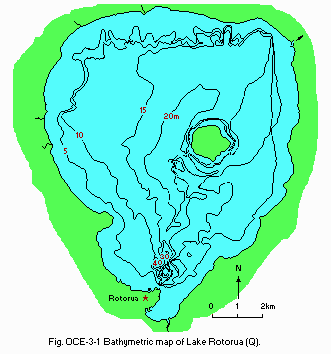
Bathymetric map (Q).
- Water temperature [deg C](4) (1977)
| Depth [m] | Jan | Feb | Mar | Apr | May | Jun | Jul | Aug | Sep | Oct | Nov | Dec |
|---|---|---|---|---|---|---|---|---|---|---|---|---|
| 0 | 18.4 | 19.9 | 21.0 | 19.4 | 14.0 | 10.0 | 9.8 | 9.8 | 9.9 | 12.9 | 14.7 | 20.8 |
| 8 | 18.4 | 19.9 | 20.9 | 19.3 | 14.0 | 10.0 | 9.8 | 9.8 | 9.8 | 12.9 | 14.7 | 18.0 |
| 14 | 18.4 | 19.9 | 20.6 | 19.1 | 13.9 | 9.9 | 9.8 | 9.8 | 9.7 | 12.7 | 14.7 | 17.4 |
| 17 | 18.4 | 19.7 | 20.4 | 18.9 | 13.9 | 9.8 | 9.8 | 9.8 | 9.6 | 12.6 | 13.8 | 17.2 |
- Freezing period: None (Q).
- Mixing type: Polymictic (Q).
- Notes on water mixing and thermocline formation
Lake Rotorua has a large surface area, extensive shallow waters and no high ground to deflect wind from any direction. As a result, its waters are wind mixed for most of the year. Calm weather in summer permits thermal stratification for periods of a few days, rarely extending for longer than 10 days.
E. LAKE WATER QUALITY
E1 TRANSPARENCY [m](4) (1977)| Jan | Feb | Mar | Apr | May | Jun | Jul | Aug | Sep | Oct | Nov | Dec |
|---|---|---|---|---|---|---|---|---|---|---|---|
| 1.8 | 3.0 | 2.0 | 2.9 | 3.2 | 2.2 | 1.8 | 2.4 | 2.1 | 2.4 | 2.6 | 2.1 |
| Depth [m] | Jan | Feb | Mar | Apr | May | Jun | Jul | Aug | Sep | Oct | Nov | Dec |
|---|---|---|---|---|---|---|---|---|---|---|---|---|
| 0 | 6.5 | 6.7 | 6.9 | 6.8 | 6.8 | 6.7 | 6.3 | 6.5 | 6.3 | 6.4 | 6.8 | 6.8 |
| 8 | 6.5 | 6.8 | 6.9 | 6.6 | 6.8 | 6.7 | 6.4 | 6.4 | 6.4 | 6.4 | 6.9 | 6.6 |
| 14 | 6.6 | 6.8 | 6.7 | 6.5 | 6.7 | 6.7 | 6.4 | 6.4 | 6.4 | 6.4 | 6.8 | 6.5 |
| 17 | 6.7 | 6.7 | 6.5 | 6.4 | 6.6 | 6.6 | 6.5 | 6.5 | 6.4 | 6.4 | 6.5 | 6.4 |
| Depth [m] | Jan | Feb | Mar | Apr | May | Jun | Jul | Aug | Sep | Oct | Nov | Dec |
|---|---|---|---|---|---|---|---|---|---|---|---|---|
| 0 | 8.9 | 8.5 | 9.1 | 9.3 | 9.8 | 11.5 | 10.7 | 11.2 | 11.5 | 10.3 | 10.2 | 9.0 |
| 8 | 9.0 | 8.6 | 9.3 | 9.3 | 9.8 | 11.5 | 10.4 | 11.2 | 11.9 | 9.9 | 10.1 | 8.3 |
| 14 | 9.0 | 8.4 | 9.3 | 6.8 | 9.8 | 11.4 | 10.1 | 11.2 | 11.3 | 9.8 | 10.0 | 7.5 |
| 17 | 9.0 | 8.1 | 7.2 | 6.1 | 9.3 | 11.3 | 9.9 | 11.1 | 11.2 | 9.7 | 8.1 | 6.6 |
| Depth [m] | Jan | Feb | Mar | Apr | May | Jun | Jul | Aug | Sep | Oct | Nov | Dec |
|---|---|---|---|---|---|---|---|---|---|---|---|---|
| 0 | 23.3 | 12.0 | 21.5 | 20.6 | 16.0 | 24.2 | 22.7 | 25.7 | 17.1 | 5.7 | 9.4 | 6.0 |
| 8 | 23.3 | 13.3 | 20.9 | 20.7 | 16.0 | 23.5 | 25.8 | 17.8 | 20.0 | 8.9 | 12.1 | 8.2 |
| 17 | 26.0 | 11.3 | 19.5 | 19.0 | 18.5 | 19.4 | 32.8 | 22.8 | 23.8 | 12.6 | 27.7 | 35.3 |
- Total-N [micro l-1] (1977)
| Depth [m] | Jan | Feb | Mar | Apr | May | Jun | Jul | Aug | Sep | Oct | Nov | Dec |
|---|---|---|---|---|---|---|---|---|---|---|---|---|
| 0 | 310 | 260 | 370 | 300 | 300 | 305 | 320 | 330 | 305 | 268 | 270 | 260 |
| 8 | 300 | 240 | 360 | 280 | 280 | 365 | 320 | 290 | 300 | 248 | 285 | 275 |
| 17 | 305 | 260 | 460 | 445 | 400 | 320 | 300 | 330 | 350 | 264 | 320 | 335 |
- Total-P [micro l-1] (1977)
| Depth [m] | Jan | Feb | Mar | Apr | May | Jun | Jul | Aug | Sep | Oct | Nov | Dec |
|---|---|---|---|---|---|---|---|---|---|---|---|---|
| 0 | 23.2 | 23.6 | 38.0 | 22.0 | 30.6 | 22.4 | 27.2 | 23.8 | 20.4 | 26.4 | 24.4 | 16.8 |
| 8 | 24.6 | 23.6 | 30.6 | 21.0 | 24.0 | 24.0 | 25.0 | 22.8 | 24.0 | 29.2 | 22.4 | 19.4 |
| 17 | 23.2 | 27.0 | 56.0 | 34.0 | 29.2 | 24.0 | 25.6 | 30.2 | 26.4 | 31.2 | 28.4 | 45.2 |
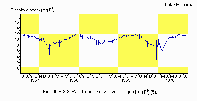
Past trend of dissolved oxygen [mg l-1](5).
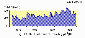
Past trend of Total-N [micro l-1](6).
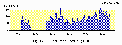
Past trend of Total-P [micro l-1](6).
F. BIOLOGICAL FEATURES
F1 FLORA- Emerged macrophytes: Negligible.
- Submerged macrophytes (Q)
Elodea canadensis, Lagarosiphon major, Egeria densa, Ceratophyllum denersum. - Phytoplankton (5)
Melosira granulata, M. distans, Mougeotia spp., Staurastrum spp., Asterionella spp., Anabaena circinalis, A. flos-aquae, Microcystis flos-aquae.
- Zooplankton
Macrocyclops albidus, Bosmina meridionalis, Calamoecia lucasi, Ceriodaphnia dubia. - Benthos
Chironomus zealandicus, Hyridella menziesi, Paranephrops planifrons, Potamopyrgus corolla. - Fish
Gobiomorphus cotidianus, Galaxias brevipinnis, Salmo gairdneri*, S. trutta, Carassius auratus, Gambusia affinis, Retropinna retropinna. * Economically important. - Supplementary notes on the biota
Occasional blooms of Limnomedusae (Craspedacusta sowerbii).
- Phytoplankton standing crop [g m-2](4)
| Year | Jan | Feb | Mar | Apr | May | Jun | Jul | Aug | Sep | Oct | Nov | Dec |
|---|---|---|---|---|---|---|---|---|---|---|---|---|
| 1975 | - | - | - | - | - | 181.0 | 168.0 | 147.0 | 60.4 | 103.8 | 53.1 | 116.9 |
| 1976 | 110.7 | 60.4 | 71.8 | 117.0 | 83.5 | 62.7 | 56.3 | 81.3 | 72.9 | 64.6 | 71.0 | 78.1 |
| 1977 | 107.7 | 45.0 | 54.2 | 52.7 | 37.6 | 142.8 | - | - | - | - | - | - |
- Primary production [g C m-2 day-1](Q)
| Year | Jan | Feb | Mar | Apr | May | Jun | Jul | Aug | Sep | Oct | Nov | Dec |
|---|---|---|---|---|---|---|---|---|---|---|---|---|
| 1974 | 1.99 | 2.72 | 3.87 | 2.29 | 1.67 | 1.36 | 1.82 | 2.54 | 1.31 | 1.86 | 1.90 | 1.82 |
| 1975 | 1.57 | 4.21 | 3.54 | 2.41 | 1.41 | 1.07 | 1.28 | 0.99 | 1.44 | 1.85 | 3.06 | 3.07 |
| 1976 | 2.57 | 4.24 | 2.94 | 3.54 | 2.08 | 1.58 | 1.52 | 1.31 | 1.63 | 1.83 | 2.09 | 4.27 |
| 1977 | 5.48 | 3.64 | 3.25 | 2.28 | 1.38 | 1.76 | 1.70 | 2.38 | 2.76 | 2.57 | 2.31 | 1.61 |
| 1978 | 1.79 | 1.81 | 2.87 | 2.93 | 1.57 | 1.24 | - | - | - | - | - | - |
- Crayfish, common up to the 1960's, has become rare or absent - a change correlated with the advent of very heavy inshore weed growth and severe eutrophication of the lake water. Successive invasions of exotic water plants have attained heavy biomass and excluded all inshore native species. Major growth of the exotic macrophytes occurred for Elodea canadensis over 1955-65, for Lagarosiphon major over 1965-75, for Egeria densa and Ceratophyllum demersum from 1975 to the present time.
G. SOCIO-ECONOMIC CONDITIONS
G1 LAND USE IN THE CATCHMENT AREA| Area [km2] | [%] | |
|---|---|---|
| Natural landscape | ||
| - Woody vegetation | 134.5 | 27.9 |
| - Herbaceous vegetation | 21.2 | 4.4 |
| - Swamp | 1.0 | 0.2 |
| Agricultural land | ||
| - Pasture land | 212.1 | 43.9 |
| Residential area | 32.3 | 6.7 |
| Lake | 81.5 | 16.9 |
| Total | 482.6 | 100 |
- Main types of woody vegetation (main species): Pinus radiata (plantation),
Beilschmiedia tawa. - Main types of herbaceous vegetation (main species): Cyathea dealbata,
Leptospermum scoparium. - Types of the other important vegetation (main species): Pasture (Lolium
perenne, Dactylis glomerata). - Main kinds of crops: Pasture, timber (mostly Pinus radiata).
- Levels of fertilizer application on crop fields: Light.
| Gross product | No. of | |||
|---|---|---|---|---|
| Gross product per year (US$1.00) | No. of persons engaged | No. of establishments | Main products or mSecondary industry | |
| Primary industry | ||||
| - Forestry | N.A. | N.A. | 2 | Pine saw logs |
| - Horticulture | 6 | N.A. | N.A. | |
| Secondary industry | N.A. | 1,100 | 5 | Sawmilling |
- Numbers of domestic animals in the catchment area
Cattle 25,000, sheep 1,250,000.
| Population | Population density [km-2] | Major cities (population) | |
|---|---|---|---|
| Urban | 54,000 | 1,700 | Rotorua |
| Rural | 12,000 | 31 | |
| Total | 66,000 | 164.1 |
H. LAKE UTILIZATION
H1 LAKE UTILIZATION- Sightseeing and tourism (no. of visitors in 1987: 919,000) and recreation (swimming, sport-fishing, yachting)
I. DETERIORATION OF LAKE ENVIRONMENTS AND HAZARDS
I1 ENHANCED SILTATION (Q)- Extent of damage: Not serious.
- Supplementary notes
Changes in lake water level caused by extremes of annual rainfall have caused concern to lakeshore residents in past years. The installation of lake outlet gates in 1980 has now greatly reduced adverse water level changes.
- Present status: Detected but not serious.
- Main contaminants, their concentrations and sources [micro g-1(wet wt.)] (1975)
| Name of contaminant | Fish* | Main sources |
|---|---|---|
| Methyl-Hg | 0.06-2.80 | Natural geothermal geysers |
- Food safety standards or tolerance limits for toxic contaminant residue
Acceptable daily intake is set at 30 micro g-1 Hg for adults. Mean methyl Hg in trout fillets of 0.85 micro (wet wt.) g-1 provides an acceptable daily intake of only 35 g.
- Nuisance caused by eutrophication (Q)
Unusual algal bloom: Anabaena spiroides. - Nitrogen and phosphorus loadings to the lake [ton yr-1](7) (1984)
| Sources | Industrial | Domestic | Agricultural & Natural | Total |
|---|---|---|---|---|
| T-N | 0 | 150 | 685 | 835 |
| T-P | 0 | 33.8 | 69 | 102.8 |
- Supplementary notes (Q, 7)
New sewage treatment is presently planned that will remove the sewage input from L. Rotorua to be in operation by 1990.
J. WASTEWATER TREATMENTS (Q)
J1 GENERATION OF POLLUTANTS IN THE CATCHMENT AREA- (d) Measurable pollution with limited wastewater treatment.
| [%] | |
|---|---|
| Non-point sources | 66 |
| Point sources | |
| - Municipal | 33 |
| - Industrial | 0 |
| Total | 99 |
- Percentage of municipal population in the catchment area provided with
adequate sanitary facilities (on-site treatment systems) or public sewerage: 100%. - Percentage of rural population with adequate sanitary facilities (on-site
treatment systems): 100%. - Municipal wastewater treatment systems
No. of tertiary treatment systems: 1 (activated sludge with simultaneous precipitation of P). No. of secondary treatment systems: 1 (activated sludge). - Industrial wastewater treatment systems
No. of industrial wastewater treatment systems: 1 (oxidation pond).
L. DEVELOPMENT PLANS (Q)
- Catchment work to reduce flooding and to protect stream banks from erosion by the Bay of Plenty Catchment Commission is nearly completed. Redesign of Rotorua City Sewage Treatment and land treatment to remove all pollutants will be completed by City Council. Works are in progress and operation is expected by 1990. Total cost is 51,000,000 NZ$ of which 21,000,000 NZ$ will be subsidized by central government.
M. LEGISLATIVE AND INSTITUTIONAL MEASURES FOR UPGRADING LAKE ENVIRONMENTS (Q)
M1 NATIONAL AND LOCAL LAWS CONCERNED- Names of the laws (the year of legislation)
- Water and Soil Conservation Act (1967)
- Section 55 of Town and Country Planning Act (1977)
- Section 2(b) of Environmental Protection and Enhancement Procedures (1981)
- Responsible authorities
- District Council (incorporating City and County Councils)
- Ministry of Works and Development
- Main items of control
- All aspects of natural water use and protection
- Dept. of Conservation (1986) Regional Office in Rotorua
- Bay of Plenty Catchment Commission and Regional Water Board (1950) in Whakatane
- Local office of Ministry of Agriculture and Fisheries
- Freshwater Ecology Unit of DSIR Taupo Research Laboratory
- Water Quality Centre of Ministry of Works and Development in Hamilton
N. SOURCES OF DATA
- Questionnaire filled by Dr. G. R. Fish, Chairman of Guardians of the Rotorua Lakes, Rotorua, New Zealand.
- Jolly, V. H. & Brown, J. M. A. (1975) New Zealand Lakes. 388 pp. Auckland University Press/Oxford University Press.
- White, E. (1977) Eutrophication of Lake Rotorua N. Z. D. S. I. S. R. Information Series 123, 16 pp.
- N. Z. Meteorology Service (Rotorua Branch) Personal communication.
- Fish, G. R. Limnological survey of Lakes Rotorua and Rotoiti, April 1975 March 1978. Unpublished data collection.
- Fish, G. R. (1975) N. Z. Fisheries Research Bulletin, No. 8, p. 68.
- Brooks, R. R., Lewis, J. R. & Reeves, R. D. (1976) N. Z. J. Mar. Freshwat. Res., 10: 233-244.
- Rutherford, J. C. & Pridmore, R. D. (1987) The significance of phosphorus and nitrogen in the management of Lake Rotorua. N. Z. Water Supply and Disposal Association Annual Conference, Rotorua, September 1987.
