
LAKE BURLEY GRIFFIN
An aerial view of the whole lake
Photo: A.Kurata
A. LOCATION
- Canberra A.C.T., Australia.
- 35:17S, 149:08E; 555.9 m above sea level.
B. DESCRIPTION
- A small artificial lake in the central part of
Canberra, the capital of Australia. The original lake emerged as part of
the 1909 proposals for the site for the National Capital. In 1911, the
competition for the design of the National Capital was carried out and
Waiter Burley Griffin, a city-planner from Chicago, won the prize in 1912.
The lake name was dedicated to him. The plan of lay-out of the city was
gazetted in 1925 including Griffin's lake.
A water feature, with three formal water basin, flanked on either side by an informal lake, was key element in Griffin's plan. National Capital Development Commission proceeded to the design and development of the lake on a two stage basis. The first stage which involved the construction of a dam, lake floor, two bridges, wharves, foreshore edges and basic landscape treatment and public facilities provision to over 843 ha of lake foreshores was officially commemorated by the Prime Minister of Australia on 17 October 1964. The second stage which is still in progress has involved detailed landscape development of the foreshores.
During both stages, an understanding of the hydraulics, water quality, ecology, biology and landscape of the lake has emerged. This understanding has had an important influence on landscape design.
The lake divides the city of Canberra into two parts, the northern section around Capital Hill for national government offices and the Diet Building, and the southern section around City Hill for down town with City Hall and shopping centres.
The commission won the Australian Institute of Landscape Architects inaugural "Award in Landscape Excellence" for its project "Lake Burley Griffin and Adjacent Parkland" in 1986. Further development of the lake foreshore is continuing in respirations of the Australian people for their National Capital (1).
C. PHYSICAL DIMENSIONS (Q1)
| Surface area [km2] | 7.1 |
| Volume [km3] | 0.033 |
| Maximum depth [m] | 17.4 |
| Mean depth [m] | 4.7 |
| Water level | Regulated |
| Length of shoreline [km] | 35.4 |
| Residence time [yr] | 0.2 |
| Catchment area [km2] | 1,865 |
D. PHYSIOGRAPHIC FEATURES
D1 GEOGRAPHICAL (Q1)- Sketch map: Fig. OCE-02-01.
- Names of main islands: The number of main islands is three.
- Number of outflowing rivers and channels (name): 1 (Molonglo R.).
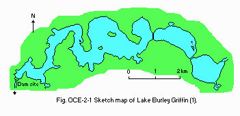
Sketch map of the lake (1).
D2 CLIMATIC (Q1)
- Climatic data at Canberra, 1941-1960
| Jan | Feb | Mar | Apr | May | Jun | Jul | Aug | Sep | Oct | Nov | Dec | Ann. | |
|---|---|---|---|---|---|---|---|---|---|---|---|---|---|
| Mean temp. [deg C] | 20.2 | 19.4 | 17.5 | 12.9 | 8.9 | 6.4 | 5.5 | 6.7 | 9.3 | 12.1 | 15.2 | 18.4 | 12.7 |
| Precipitation [mm] | 63 | 59 | 60 | 47 | 59 | 47 | 43 | 40 | 43 | 72 | 63 | 55 | 651 |
- Number of hours of bright sunshine: 2,622 hr yr-1.
- Snowfall: None.
- Water temperature [deg C]
| Central Lake | |||||||||||
| Jan | Feb | Mar | Apr | May | Jun | Jul | Aug | Sep | Oct | Nov | Dec |
|---|---|---|---|---|---|---|---|---|---|---|---|
| 22 | 22 | 19 | 15 | 10 | 8 | 7 | 10 | 13 | 15 | 20 | 21 |
E. LAKE WATER QUALITY
E1 TRANSPARENCY [m](Q1)- Central lake, 1976-1977
Winter: 2.0 (1.4-2.4).
Summer: 1.4 (0.8-2.3).
- Central lake, 1976-1977
Winter: 7.5 (6.6-8.6).
Summer: 7.1 (6.4-7.7).
| Central lake, 1976-1977 | ||
| Depth [m] | Winter | Summer |
|---|---|---|
| Surface | 10.8 (9.4-12.5) | 7.4 (6.7-7.8) |
| Bottom | 10.6 (8.2-12.6) | 5.1 (2.6-7.9) |
- Total-P [mg l-1]
| Central lake, 1979-1980 | ||||||||||||
| Depth [m] | Jan | Feb | Mar | Apr | May | Jun | Jul | Aug | Sep | Oct | Nov | Dec |
|---|---|---|---|---|---|---|---|---|---|---|---|---|
| - | .034 | .036 | .034 | .034 | .036 | - | - | - | - | - | .039 | .082 |
F. BIOLOGICAL FEATURES
F1 FLORA (Q1)- Emerged macrophytes: Typha sp.
- Floating macrophytes: Azolla sp.
- Submerged macrophytes
- Phytoplankton: Microcystis sp., Anabaena sp., Anacystis sp., Volvox sp.
Potamogeton crispus, Vallisneria gigantea, Egeria densa.
- Zooplankton
- Fish
Cladocera (Bosmina sp., Ceriodaphnia sp., Daphnia sp.), Cyclopoda (Cyclops sp.), Calanoida (Boeckella sp., Calamoecia sp.).
Salmo gairdneri, S. trutta, Cyprinus carpio, Galaxias bongbong, Gambusia sp.
G. SOCIO-ECONOMIC CONDITIONS
G1 LAND USE IN THE CATCHMENT AREA (Q1)| Area [km2] | [%] | |
|---|---|---|
| Natural landscape | ||
| - Woody vegetation | 690 | 37 |
| Agricultural land | 1,116 | 60 |
| Residential area | 59 | 3 |
| Total | 1,865 | 100 |
- Main types of woody vegetation (main species): Savanna woodland,
- Main types of herbaceous vegetation (Q1, Q2)
dry sclerophyll forest (Eucalyptus spp.).
Poa and Stipa grassland. Grazing mostly on native pasture (36%), cropping in ca. 1% and the rest is improved pasture.
| No. of persons engaged | Main products or major industries | |
|---|---|---|
| Primary industry | ||
| - Agriculture | 3,000 | Beef, lamb, wool |
| - Fisheries | 40 | |
| Secondary industry | ||
| - Manufacturing | 3,000 | |
| - Mining | 30 | |
| Tertiary industry | 9,000 | |
| Population | Population density [km-2] | Major cities (population) | |
|---|---|---|---|
| Total | 250,000 | 134.5 | Canberra (250,000) |
H. LAKE UTILIZATION
H1 LAKE UTILIZATION (Q1)- Source of water, tourism and recreation (swimming, sport-fishing, yachting).
| Use rate [m3 sec-1] | |
|---|---|
| Irrigation | 5.71 |
I. DETERIORATION OF LAKE ENVIRONMENTS AND HAZARDS
I3 EUTROPHICATION (Q2)- Nuisance caused by eutrophication
- Nitrogen and phosphorus loadings to the lake [t yr-1] (1983)
Unusual bloom of blue-green algae; macrophyte blocking recreational use.
| Sources | Industrial | Domestic | Agricultural | Natural | Total |
|---|---|---|---|---|---|
| T-N | 2.5 | 74.5 | 240 | 132 | 449.0 |
| T-P | 0.5 | 12.7 | 12 | 6.6 | 31.8 |
J. WASTEWATER TREATMENTS
J1 GENERATION OF POLLUTANTS IN THE CATCHMENT AREA- (d) Measurable pollution with limited wastewater treatment.
- Municipal and industrial wastewater treatment systems
No. of municipal and industrial wastewater treatment systems: 1 (activated sludge, trickle sludge and trickling filter); rate of treatment 15,068 m3 day- 1.
L. DEVELOPMENT PLANS (1)
- Two significant projects are currently in design: the National Museum
of Australia on the western shore of Yarramundi Beach and major landscaping
of the southern foreshore of Central Basin consequent to the Government's
decision to build the new Parliament House on Capital Hill instead of the
lake foreshore.
K. IMPROVEMENT WORKS IN THE LAKE
- Supplementary notes (Q1, Q2)
- Improvement works.
- Presently removing phosphorus in summer from upstream sewage effluent.
- Stabilization of old sulfide mine waste dump in 1974-1975.
M. LEGISLATIVE AND INSTITUTIONAL MEASURES FOR UPGRADING LAKE
- ENVIRONMENTS
- Name of the law (the year of legislation)
- Water pollution ordinance (in preparation)
N. SOURCES OF DATA
- Questionnaire filled by Dr. P. Collen, Canberra College of Advanced Education, Australia. (Q1)
- Questionnaire filled by Dr. B. H. Pratt, Conservation & Agriculture, Department of Territories and Local Government, Australia. (Q2)
- National Capital Development Commission (1986) The Lake News, School Project Series, June 1986.
- National Capital Development Commission (1986) Canberra, From Limestone Plains to Garden City, The Story of the National Capital's Landscape, 92 pp.
