
LAKE TAUPO
On the lakeshore at Taupo
Photo: A.Kurata
A. LOCATION
- South Auckland-Bay of Plenty, New Zealand.
- 38:45S, 175:55E; 357 m above sea level.
B. DESCRIPTION
-
Lake Taupo is located at the centre of the North Island of New Zealand, and is the largest in that country. The drainage basin of the lake is characterized by a mild climate; moderate temperature, light winds, cool summers, relatively warm winters and a fairly even distribution of rainfall throughout the year. The lake is surrounded by gently sloping hills which offer pasture for sheep. About 30 rivers flow into the lake, while the Waikato River is the only outlet. There are two towns, large and small, around the lake. Taupo is the main town which is located at the mouth of the Waikato River. Tall eucalypti, which are characteristic in New Zealand and Australia, are abundant on the lake shore of the town. The lake water is clear and highly transparent, with a maximum transparency of 21 m. The concentration of nitrogen and the nitrogen/phosphorus ratio of the water are remarkably low. This may be mainly attributed to the geology of the catchment area, and is responsible for the oligotrophic level of its productivity. The Koaro and the Toitoi are fish native to the lake. The Koaro, with a flat head and tough but slimy skin, was an important fish resource for the Maori living around the lake, but has become very scarce. On the other hand, artificially stocked rainbow trout is now abundant, and is primarily important for sport-fishing. The common smelt was also introduced to the lake between 1934 and 1940 after the average size of trout declined (2).
C. PHYSICAL DIMENSIONS
| Surface area [km2] | 616 |
| Volume [km3] | 60 |
| Maximum depth [m] | 164 |
| Mean depth [m] | 91 |
| Water level | Regulated |
| Length of shoreline [km] | 153 |
| Residence time [yr] | 10.6 |
| Catchment area [km2] | 3,327 |
D. PHYSIOGRAPHIC FEATURES
D1 GEOGRAPHICAL- Bathymetric map: Fig. OCE-01-01.
- Names of main islands: None.
- Number of outflowing rivers and channels (name): 1 (Waikato R.).
- Climatic data at Taupo, 1949-1970 (1)
| Jan | Feb | Mar | Apr | May | Jun | Jul | Aug | Sep | Oct | Nov | Dec | Ann. | |
|---|---|---|---|---|---|---|---|---|---|---|---|---|---|
| Mean temp. [deg C] | 17.1 | 17.3 | 15.6 | 12.5 | 9.6 | 7.3 | 6.3 | 7.4 | 9.3 | 11.5 | 13.5 | 15.6 | 11.9 |
| Precipitation [mm]* | 1,200 | ||||||||||||
- Snowfall: None.
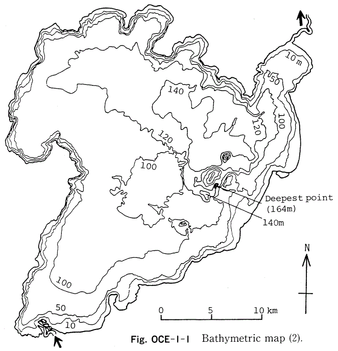
Bathymetric map (2).
- Water temperature [deg C](1)
| Lake centre, 1974-1976 | ||||||||||||
| Depth [m] | Jan | Feb | Mar | Apr | May | Jun | Jul | Aug | Sep | Oct | Nov | Dec |
|---|---|---|---|---|---|---|---|---|---|---|---|---|
| S* | 22 | 20 | 18 | 16 | 13 | 12 | 11 | 11 | 13 | 15 | 18 | 20 |
- Freezing period: None.
- Mixing type: Monomictic.
- Notes on water mixing and thermocline formation
The thermocline is formed from December to June.
E. LAKE WATER QUALITY
E1 TRANSPARENCY [m](1)| Lake centre, 1974-1976 | |||||||||||
| Jan | Feb | Mar | Apr | May | Jun | Jul | Aug | Sep | Oct | Nov | Dec |
|---|---|---|---|---|---|---|---|---|---|---|---|
| - | - | 15 | 15 | - | - | - | 11 | 11 | - | 20 | 20 |
| Lake centre, 1974-1976 | ||||||||||||
| Depth [m] | Jan | Feb | Mar | Apr | May | Jun | Jul | Aug | Sep | Oct | Nov | Dec |
|---|---|---|---|---|---|---|---|---|---|---|---|---|
| S* | 7.4 | 8.1 | - | 8.4 | 7.9 | 7.3 | 7.2 | 7.5 | 7.0 | 7.6 | 7.3 | 7.5 |
- Lake outlet: 0.5-1.0 (estimated range).
- Lake centre, 1974-1976: Saturated at all times above 75 m depth.
| Lake centre, 1975-1976 | ||||||||||||
| Depth [m] | Jan | Feb | Mar | Apr | May | Jun | Jul | Aug | Sep | Oct | Nov | Dec |
|---|---|---|---|---|---|---|---|---|---|---|---|---|
| 0-30 | 1.0 | 1.0 | 1.0 | 0.8 | 1.0 | 1.2 | 1.7 | 2.8 | 2.4 | 2.0 | 1.2 | 1.1 |
- NO3-N [micro l-1]
| Lake centre, 1975-1976 | ||||||||||||
| Depth [m] | Jan | Feb | Mar | Apr | May | Jun | Jul | Aug | Sep | Oct | Nov | Dec |
|---|---|---|---|---|---|---|---|---|---|---|---|---|
| *1 | 0.6 | 2.2 | 1.0 | 0.3 | 0.4 | 0.3 | 1.0 | 1.0 | 0.4 | 0.6 | 0.8 | 0.4 |
| *2 | 14 | 17 | 18 | 17 | 20 | 21 | 23 | 2 | 3 | 1 | 7 | 9 |
- NH4-N [mg l-1]
| Lake centre, 1975-1976 | ||||||||||||
| Depth [m] | Jan | Feb | Mar | Apr | May | Jun | Jul | Aug | Sep | Oct | Nov | Dec |
|---|---|---|---|---|---|---|---|---|---|---|---|---|
| *1 | .014 | .007 | .005 | .004 | .002 | .002 | .002 | .006 | .002 | .004 | - | .009 |
| *2 | .007 | .006 | .005 | .002 | .001 | .002 | .003 | .003 | .003 | .005 | - | .006 |
- Total-P [mg l-1]*
| Lake centre, 1975-1976 | ||||||||||||
| Depth [m] | Jan | Feb | Mar | Apr | May | Jun | Jul | Aug | Sep | Oct | Nov | Dec |
|---|---|---|---|---|---|---|---|---|---|---|---|---|
| - | .006 | .004 | .005 | .001 | .008 | .007 | .009 | .010 | .012 | .006 | .005 | .002 |
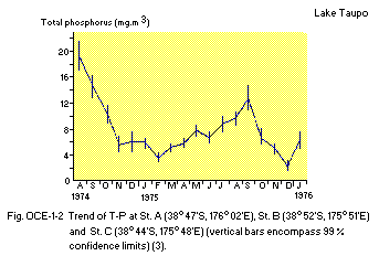
Trend of T-P at Station A (38:47S, 176:02E), Station B (38:52S, 175:51E) and Station C (38:44S, 175:48E)(vertical bars encompass 99% confidence limits)(3).
F. BIOLOGICAL FEATURES
F1 FLORA- Submerged macrophytes
- Phytoplankton
Chara corallina, Nitella hyalina, N. flexilis, N. hookeri, Elodea canadensis, Lagarosiphon major, Potamogeton crispus.
Melosira granulata, Asterionella formosa, Chroococcus spp., Ankistrodesmus spp., Cyclotella spp.
- Zooplankton
- Benthos
- Fish
- Supplementary notes on the biota: Fig. OCE-01-03.
Crustacea (Boeckella propinqua, Macrocyclops albidus, Ceriodaphnia dubia, Bosmina meridionalis, Daphnia carinata); Rotifera (Polyarthra vulagris, Pompholyx sp., Asplanchna brightwelli).
Paranephrops planifrons, Chironomus zealandicus, Potamopyrgus antipodarum, Lymmaea stagnalis, Cyraulus corinna, Hyridella menziesi.
Galaxias brevipinnis, Gobiomorphus cotidianus, Retropinna retropinna, Salmo trutta, S. gairdneri.
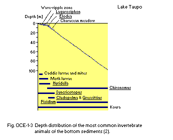
Depth distribution of the most common invertebrate animals of the bottom sediments (2).
F5 FISHERY PRODUCTS (2)
- Annual fish catch [metric tons]
1966-1967: 671.

Average weight of rainbow trout in anglers' bags in Lake Taupo; catchment every five year since 1905. Separate points are shown for years 1911, 1917 and 1924. These years mark maximum peaks and troughs at a critical period of the fishery (2).
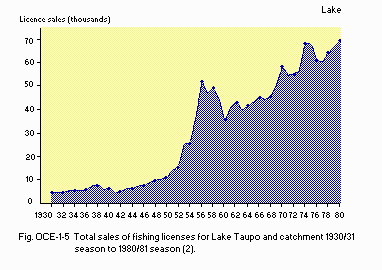
Total sales of fishing licenses for Lake Taupo and catchment 1930/31 season to 1980/81 season (2).
G. SOCIO-ECONOMIC CONDITIONS
G1 LAND USE IN THE CATCHMENT AREA (Q1) (1973)| Area [km2] | [%] | |
|---|---|---|
| Natural landscape | ||
| - Indigenous forest (including alpine and subalpine vegetation) | 75.6 | 28 |
| - Tree plantation (exotic) | 36.3 | 14 |
| - Scrub | 69.8 | 26 |
| - Tussock grassland | 33.7 | 13 |
| Agricultural land | ||
| - Pasture land | 46.9 | 18 |
| Residential area | 3.2 | 1 |
| Total | 265.5 | 100 |
- Main types of woody vegetation
Mixed evergreen broadleaf/conifer forest (Nothofagus, Podocarpus); pine plantation (Pinus radiata); lowland scrub (Leptospermum, Coriaria). - Main types of herbaceous vegetation
Tussock grassland; clover-ryegrass pasture.
| No. of persons engaged | Main products or major industries | |
|---|---|---|
| Primary industry | ||
| - Agricultural | 282 | Meat, wool, logs and posts |
| Secondary industry | ||
| - Manufacturing | 978 | |
| - Mining | 9 | |
| - Others | 572 | |
| Tertiary industry | 3,627 | |
| Population | Population density [km-2] | Major cities (population) | |
|---|---|---|---|
| Total | 25,500 | 7.7 | Taupo, Turangi |
H. LAKE UTILIZATION (Q1)
H1 LAKE UTILIZATION- Source of water, sightseeing and tourism, recreation (swimming, sport-fishing, yachting).
| Use rate [m3 sec-1] | |
|---|---|
| Domestic | 0.10 |
| Power plants* | N.A. |
I. DETERIORATION OF LAKE ENVIRONMENTS AND HAZARDS
I1 ENHANCED SILTATION- Extent of damage: Not serious.
- Present status: None.
- Nuisance caused by eutrophication: Not any nuisance.
- Nitrogen and phosphorus loadings to the lake [t yr-1](Q1, 1) (1973-1974)
| Sources | Agricultural | Natural | Total |
|---|---|---|---|
| T-N | Minor | Major | 657 |
| T-P | Minor | Major | 116 |
- Extent of damage: None.
J. WASTEWATER TREATMENTS
J1 GENERATION OF POLLUTANTS IN THE CATCHMENT AREA- (b) No sources of significant pollution.
- Municipal wastewater treatment systems
No. of secondary treatment systems: 1 (more under construction; activated sludge and oxidation pond).
No. of other types: Many of the urban communities near the shores of the lake use septic tanks to dispose of wastewater.
K. IMPROVEMENT WORKS IN THE LAKE
K1 RESTORATION (2)- Lake Taupo Catchment Control Scheme, Soil Conservation, Run-off Control and Water Management in the total catchment of 266,000 ha. Implementation period: 1974-1987. Approximate total cost: NZ$ 6,000,000.
L. DEVELOPMENT PLANS (Q2)
- Water diversions and power stations are planned in the catchment area. The diagram of the Tongariro Power Development Scheme is shown in Fig. OCE-01-06.
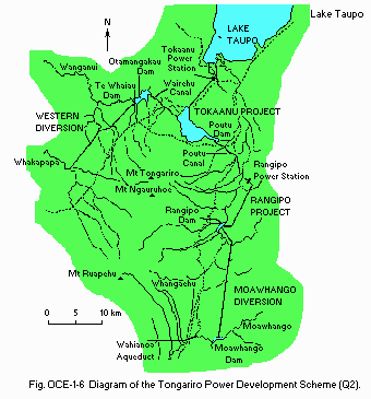
Diagram of the Tongariro Power Development Scheme.
M. LEGISLATIVE AND INSTITUTIONAL MEASURES FOR UPGRADING LAKE ENVIRONMENTS (Q1,Q2)
M1 NATIONAL AND LOCAL LAWS CONCERNED- Names of the laws (the year of legislation)
- Soil conservation and Rivers Control Act (1941)
- Water and Soil Conservation Act (1967)
- Local Government Act (1974)
- Town and Country Planning Act (1977)
- Responsible authorities
- Taupo County Council
- Waikato Valley Authority
- Tongariro United Council
- Main items of control
- Water rights
- Soil conservation works
- District schemes
- Clearance of ground cover by-law and subdivisional controls
- Waikato Valley Authority
- Electricity Division, Ministry of Energy
- Department of Internal Affairs
- Federation of Lake Taupo Angling. Shooting and Boating Societies
- Lake Taupo Advisory Committee
- New Zealand Forest Service
- Department of Lands and Survey
- Tongariro-Taupo Parks and Reserves Board
- Taupo and Taumarnui County Councils
- Ministry of Works and Development
- DSIR-Taupo Research Laboratory
- Aquatic Weeds Section of Ministry of Agriculture and Fisheries
- Fisheries Research Division of Ministry of Agriculture and Fisheries
- Department of Internal Affairs-Wildlife Service
N. SOURCES OF DATA
- Questionnaire filled by the Department of Scientific and Industrial Research. (Q1)
- Questionnaire filled by Dr. D. G. Smith, National Water and Soil Conservation Organization. (Q2)
- Data supplied by Dr. M. Timperley, Ecology Division, Department of Scientific and Industrial Research.
- Forsyth, D. J. & Howard-Williams, C. (1983) Lake Taupo, Ecology of a New Zealand Lake. New Zealand Department of Scientific and Industrial Research, Information Series No. 158. 163 pp. Science Information Publishing Centre, DSIR, Wellington.
- White, E., Downes, M., Gibbs, M., Kemp, L., Mackenzie, L. & Payne, G. (1980) Aspects of the physics, chemistry, and phytoplankton biology of Lake Taupo. N. Z. J. Mar. Freshw. Res., 14: 139-148.
