LAKE SALTO GRANDE
An aerial view of the dam

Photo: Comision Tecnica Mixta de Salto Grande
A. LOCATION
- Entre Rios, Argentina; and Artigas and Salto, Uruguay.
- 29:43-31:12S, 57:06-57:55W; 35 m above sea level.
B. DESCRIPTION
Lake Salto Grande is an artificial lake built on the Uruguay River, which forms the boundary between Argentina and Uruguay, at about 450 km from Buenos Aires and about 500 km from Montevideo. The reservoir is 144 km long and about 9 km wide, covering an area of 783 km2. Its western shore belongs to the Province of Entre Rios of Argentina, and the eastern shore is shared by two provinces of Uruguay. The catchment area covers 224,000 km2 extending over the territories of the two countries.
The impoundment was initiated in 1973 after a long period of negotiation between the two countries since 1964. The reservoir was constructed and managed by the Comision Tecnica Mixta de Salto Grande in which Argentina and Uruguay participate evenly in both operational and financial aspects. The creation of the reservoir resulted in the submergence of a town with 22,000 inhabitants, though the town has been relocated at some distance from the dam site. The produced electricity is supplied to both countries. The supply to Uruguay side very often surpasses the whole consumption in Montevideo.
Because of its proximity to such cities as Concordia (Argentina) and Salto (Uruguay), L. Salto Grande is an important recreational center. The surrounding area made a public park with various facilities (an airport, harbors, auditoria and camping sites) soon after the reservoir was formed. Since there are vast flat plain with many residential areas in the upstream of the reservoir, accelerated soil erosion in the rainy season and resultant siltation offer a prevailing problem in spite of the afforestation efforts around the reservoir (Q, 1, 2).
C. PHYSICAL DIMENSIONS
| Surface area [km2] | 783 |
| Volume [km3] | 5.0 |
| Maximum depth [m] | 33 |
| Mean depth [m] | 6.4 |
| Water level | Regulated |
| Normal range of annual water level fluctuation [m] | 0.8 |
| Length of shoreline [km] | 1,190 |
| Residence time [yr] | 0.031 |
| Catchment area [km2] | 224,000 |
D. PHYSIOGRAPHIC FEATURES
D1 GEOGRAPHICAL
- Sketch map: Fig. SAM-12-1.
- Number of main islands: None.
- Number of outflowing rivers and channels (name): 1 (R. Uruguay).
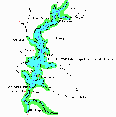
Fig. SAM-12-01
Sketch map (1, 2).
D2 CLIMATIC
- Climatic data at Concordia, 1931 1960 (3)
| Jan | Feb | Mar | Apr | May | Jun | Jul | Aug | Sep | Oct | Nov | Dec | Ann. |
|---|
| Mean temp. [deg C] | 25.7 | 24.7 | 22.6 | 18.3 | 15.5 | 13.2 | 12.5 | 13.6 | 15.1 | 18.3 | 21.4 | 24.2 | 18.8 |
| Precipitation [mm] | 128 | 109 | 154 | 136 | 82 | 87 | 56 | 65 | 88 | 117 | 96 | 96 | 1,214 |
- Water temperature [deg C]
| Near the dam, 1982 1989 (4) |
| Depth [m] | Jan | Feb | Mar | Apr | May | Jun | Jul | Aug | Sep | Oct | Nov | Dec |
|---|
| S*1 | 27.6 | 26.5 | 23.8 | 18.3 | 19.8 | 17.6 | 14.4 | 16.2 | 17.8 | 19.6 | 23.1 | 24.9 |
| B*2 | 27.0 | 25.8 | 23.5 | 18.6 | 19.5 | 17.8 | 14.6 | 15.8 | 17.6 | 19.6 | 22.1 | 24.3 |
*1 Surface. *2 Bottom.
- Freezing period: None.
- Mixing type: Polymictic.
E. LAKE WATER QUALITY (4)
E1 TRANSPARENCY
| Near the dam, 1982 1989 |
| Depth [m] | Jan | Feb | Mar | Apr | May | Jun | Jul | Aug | Sep | Oct | Nov | Dec |
|---|
| 0.7 | 0.3 | 0.3 | 0.5 | 0.4 | 0.5 | 0.2 | 0.4 | 0.4 | 0.2 | 0.3 | 0.4 |
E2 pH
| Near the dam, 1982 1989 |
| Depth [m] | Jan | Feb | Mar | Apr | May | Jun | Jul | Aug | Sep | Oct | Nov | Dec |
|---|
| S*1 | 7.3 | 7.4 | 7.3 | 7.1 | 7.2 | 7.4 | 7.3 | 7.2 | 7.3 | 7.4 | 7.3 | 7.3 |
| B*2 | 7.3 | 7.4 | 7.2 | 7.0 | 7.3 | 7.4 | 7.2 | 7.3 | 7.4 | 7.4 | 7.3 | 7.3 |
*1 Surface. *2 Bottom.
E4 DO [mg l-1]
| Near the dam, 1982 1989 |
| Depth [m] | Jan | Feb | Mar | Apr | May | Jun | Jul | Aug | Sep | Oct | Nov | Dec |
|---|
| S*1 | 7.4 | 6.8 | 7.0 | 7.8 | 7.8 | 8.8 | 9.1 | 9.3 | 8.7 | 8.0 | 7.6 | 6.9 |
| B*2 | 6.5 | 6.4 | 7.2 | 7.5 | 7.8 | 8.8 | 9.2 | 9.4 | 8.6 | 8.1 | 7.7 | 6.3 |
*1 Surface. *2 Bottom.
E5 COD [mg l-1]
Determined by K2Cr2O7 method.
| Near the dam, 1982 1989 |
| Depth [m] | Jan | Feb | Mar | Apr | May | Jun | Jul | Aug | Sep | Oct | Nov | Dec |
|---|
| S*1 | 2.1 | 3.6 | 4.2 | 4.9 | 2.9 | 2.6 | 3.2 | 3.6 | 2.7 | 4.0 | 4.7 | 3.3 |
| B*2 | 2.6 | 4.1 | 2.0 | 6.3 | 3.0 | 2.7 | 3.2 | 3.3 | 1.8 | 3.1 | 5.1 | 5.6 |
*1 Surface. *2 Bottom.
E6 CHLOROPHYLL CONCENTRATION [micro g l-1]
| Near the dam, 1982 1989 |
| Depth [m] | Jan | Feb | Mar | Apr | May | Jun | Jul | Aug | Sep | Oct | Nov | Dec |
|---|
| S* | 3.3 | 2.3 | 4.2 | 1.7 | 5.1 | 1.3 | 0.1 | 3.6 | 2.4 | 2.1 | 7.0 | 2.5 |
* Surface.
E8 PHOSPHORUS CONCENTRATION
| Near the dam, 1982 1989 |
| Depth [m] | Jan | Feb | Mar | Apr | May | Jun | Jul | Aug | Sep | Oct | Nov | Dec |
|---|
| S*1 | 0.08 | 0.05 | 0.05 | 0.06 | 0.07 | 0.06 | 0.11 | 0.08 | 0.08 | 0.07 | 0.06 | 0.09 |
| B*2 | 0.06 | 0.05 | 0.06 | 0.03 | 0.08 | 0.10 | 0.07 | 0.08 | 0.09 | 0.08 | 0.07 | 0.09 |
*1 Surface. *2 Bottom.
F. BIOLOGICAL FEATURES (4)
F1 FLORA
- Emerged macrophytes: None.
- Floating macrophytes: None.
- Submerged macrophytes: None.
- Phytoplankton
Later spring beginning summer: Diatoms.
Summer: Cyanophyceae.
Autumn winter early spring: All groups are equivalent.
F2 FAUNA
- Zooplankton: Rotifera and Cladocera dominant in summer.
- Fish
Prapimelodus valenciensis, Lycengraulis grossidens, Pachyurus bonariensis, Leporinus obtusidens, Prochilodus lineatus*, Salminus brasiliensis*, Pterodoras granulosus, Luciopimelodus pati* (* economically important).
F4 BIOMASS
- Biomass of zooplankton [ind. m-3]
Summer: 20,000 40,000.
Autumn winter and spring: 2,000 5,000.
F5 FISHERY PRODUCTS
N.A.
G. SOCIO-ECONOMIC CONDITIONS (4)
G1 LAND USE IN THE CATCHMENT AREA
| 1984 |
| Area [km2]* |
|---|
| Natural landscape | 960 |
| Agricultural land | 46.3 |
| Residential area | 49.1 |
| Total | 1,055.4 |
* This table is concerned only with the part of the catchment area from Salto Grande Dam to Paso de los Libres City (about 200 km upstream from the dam).
- Main types of forest vegetation: Pine-eucalyptus plantation.
- Main kinds of crops: Rice.
- Levels of fertilizer application on crop fields: Moderate.
- Trends of change in land use in recent years: None.
H. LAKE UTILIZATION (Q)
H1 LAKE UTILIZATION
Source of water, navigation and transportation, sightseeing and tourism, recreation (swimming, yachting, sport-fishing) and fisheries.
H2 THE LAKE AS WATER RESOURCE
| 1990 |
| Use rate [m3 sec 1] |
|---|
| Power plant | 5,500 | 45,000 MWh maximum daily capacity |
I. DETERIORATION OF LAKE ENVIRONMENTS AND HAZARDS (Q)
I1 ENHANCED SILTATION
- Extent of damage: Not serious.
I2 TOXIC CONTAMINATION
- Present status: Detected but not serious.
I3 EUTROPHICATION
- Nuisance caused by eutrophication
Unusual algal bloom: Microcystis, Anabaena and Alaucoseria.
- Phosphorus loading to the lake [t yr-1]
| 1984 |
| Source | Industrial | Domestic | Agricultural | From upstream | Total |
|---|
| T-P | - | 49 | 2,344 | 4,848 | 7,241 |
I4 ACIDIFICATION
J. WASTEWATER TREATMENTS (Q)
J1 GENERATION OF POLLUTANTS IN THE CATCHMENT AREA
d) Measurable pollution with limited wastewater treatment.
J2 APPROXIMATE PERCENTAGE DISTRIBUTION OF POLLUTANT LOADS
| [%] |
|---|
| Non-point sources | 100 |
| Total | 100 |
K. IMPROVEMENT WORKS IN THE LAKE (Q)
None.
M. LEGISLATIVE AND INSTITUTIONAL MEASURES FOR UPGRADING LAKE ENVIRONMENTS
M1 NATIONAL AND LOCAL LAWS CONCERNED
- Responsible authorities
- Comision Tecnica Mixta de Salto Grande
M3 RESEARCH INSTITUTES ENGAGED IN THE LAKE ENVIRONMENT STUDIES
- Comision Tecnica Mixta de Salto Grande
N. SOURCES OF DATA
- Questionnaire filled by Dr. R. H. Ancarola, Comision Tecnica Mixta de Salto Grande, Concordia, Argentina.
- Mascimo, C. A. & Ancarola, R. H., personal communication.
- The editor's observation.
- Prohaska, F. (1976) The Climate of Argentina, Paraguay and Uruguay. "World Survey of Climatology, Volume 12, Climates of Central and South America" (ed. Schwerdtfeger, W.), pp. 13 112. Elsevier Publishing Company, Amsterdam-London-New York.
- Papers and reports from DPTO Ecologia y Medio Ambiente C.T.M. Salto Grande.

