
LAKE TODOS LOS SANTOS
A lake view from the eastern end at Peulla
Photo: A.Kurata
A. LOCATION
- Los Lagos, Chile.
- 41:08S, 72:12W; 189 m above sea level.
B. DESCRIPTION
-
Lake Todos los Santos is located in the Andean pre-mountain range in the Araucanian lake district of southern Chile within the latitudinal range of 39-42S. Lakes in the district have many biotic and abiotic characteristics in common, but differ in the extent of their oligotrophy.
L. Todos los Santos has a surface area of 178.5 km2 and a large volume owing to its great depth reaching a maximum of 337 m. The catchment area of the lake is fairly wide, being 17 times as wide as the lake surface. Its origin is both glacial and volcanic. During in the Ice Age, two glacier arms, one flowing down southward through the present Negro River valley and the other in the opposite direction through the Blanco River valley, converged in the central valley and advanced westward excavating the tertiary valley to form the depression now occupied by Lakes Todos los Santos and Llanquihue. After the disappearance of the ice, the action of Osorno and Calbuco Volcanoes divided the two lake basins with volcanic matters. Matters from Tronador Volcano also reached the lake via Blanco River glacier.
The lake is warm monomictic and oligotrophic. The concentration of major nutrients are low. The highest carbon assimilation rate per unit amount of chlorophyll occurs in winter, but the primary production reaches its highest level at the beginning of summer, though the productivity itself is low (1, 2).
C. PHYSICAL DIMENSIONS
| Surface area [km2] | 178.5 |
| Volume [km3] | 34.4 |
| Maximum depth [m] | 337 |
| Mean depth [m] | 191 |
| Length of shoreline [km] | 125 |
| Residence time [yr] | 4 |
| Catchment area [km2] | 3,036 |
D. PHYSIOGRAPHIC FEATURES
D1 GEOGRAPHICAL- Bathymetric map: Fig. SAM-11-1.
- Number of main islands (name and area): Cabras.
- Number of outflowing rivers and channels (name): 1 (Petrohue R.).
- Climatic data at Puerto Montt*, 1911 1959 (3)
| Jan | Feb | Mar | Apr | May | Jun | Jul | Aug | Sep | Oct | Nov | Dec | Ann. | |
|---|---|---|---|---|---|---|---|---|---|---|---|---|---|
| Mean temp. [deg C] | 15.2 | 14.8 | 13.2 | 11.2 | 9.3 | 8.0 | 7.6 | 7.8 | 8.8 | 10.6 | 12.2 | 13.9 | 11.1 |
| Precipitation [mm] | 90 | 139 | 139 | 181 | 236 | 257 | 209 | 197 | 158 | 119 | 131 | 125 | 1,981 |
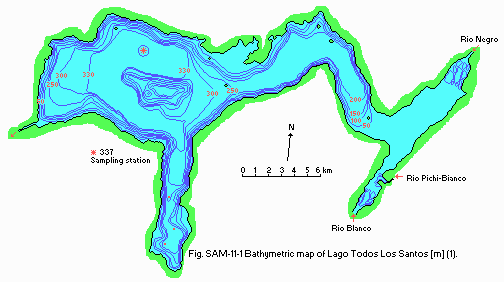
Bathymetric map [m](1).
- Water temperature [deg C]
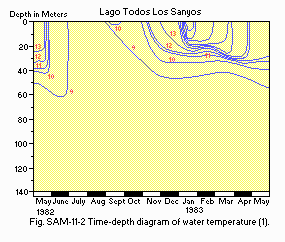
Time-depth diagram of water temperature (1).
- Freezing period: None.
- Mixing type: Monomictic.
- Notes on water mixing and thermocline formation
The winter circulation results in a homeothermy between 8.1 8.8deg C with a small difference between surface and bottom. Surface layers begin to warm up in the beginning of spring, the heat penetrating to a depth of 62 m.
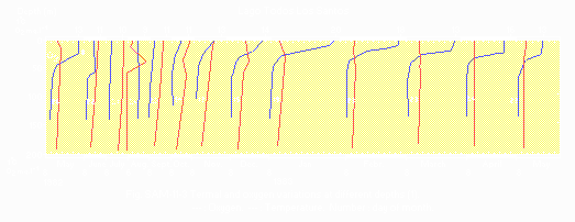
Thermal and oxygen variations at different depths (1).
E. LAKE WATER QUALITY (1)
E1 TRANSPARENCY [m]-
Center of the main basin (Fig. SAM-11-1), 1982 1983.
Winter (June) 4; spring (December) 13; mean 10.2.
- Center of the main basin, 1982 1983
| Depth Jan | Feb | Mar | Apr | May | Jun | Jul | Aug | Sep | Oct | Nov | Dec |
|---|---|---|---|---|---|---|---|---|---|---|---|
| Mean* 7.0 | 6.6 | 6.5 | 7.5 | 7.4 | 6.9 | 7.0 | 6.7 | 7.1 | 7.1 | 7.0 | 7.6 |
| 1982 1983 | ||||||||||||
| Depth Jan | Feb | Mar | Apr | May | Jun | Jul | Aug | Sep | Oct | Nov | Dec | |
|---|---|---|---|---|---|---|---|---|---|---|---|---|
| Mean | 10.2 | 9.9 | 10.3 | 9.8 | 9.6 | 10.2 | 10.8 | 7.7 | 10.6 | 10.6 | 10.9 | 10.9 |
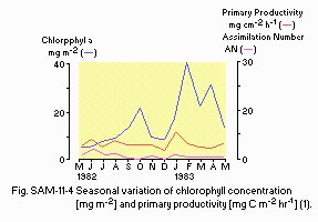
Seasonal variation of chlorophyll concentration [mg m-2] and primary productivity [mg C m-2 hr 1](1).
E7 NITROGEN CONCENTRATION
- NO3-N [mg l-1]
| 1982 1983 | ||||||||||||
| Depth [m] | Jan | Feb | Mar | Apr | May | Jun | Jul | Aug | Sep | Oct | Nov | Dec |
|---|---|---|---|---|---|---|---|---|---|---|---|---|
| 0.1 | 0.01 | 0.02 | 0.15 | 0.08 | 0.26 | 0.08 | 0.18 | 0.01 | 0.02 | 0.14 | 0.02 | 0.01 |
| 15 | 0.02 | 0.01 | 0.13 | 0.09 | 0.27 | 0.11 | 0.01 | 0.01 | 0.02 | 0.14 | 0.03 | 0.01 |
| 40 | 0.02 | 0.04 | 0.14 | 0.11 | 0.23 | 0.06 | 0.01 | 0.01 | 0.02 | 0.15 | 0.03 | 0.01 |
| 60 | 0.01 | - | 0.11 | 0.10 | 0.34 | 0.11 | 0.03 | 0.01 | 0.02 | 0.16 | 0.02 | 0.01 |
| 200 | 0.10 | 0.08 | 0.13 | 0.10 | 0.19 | 0.11 | 0.06 | 0.03 | 0.04 | 0.17 | 0.06 | 0.07 |
- PO4-P [micro g l-1]
| 1982 1983 | ||||||||||||
| Depth [m] | Jan | Feb | Mar | Apr | May | Jun | Jul | Aug | Sep | Oct | Nov | Dec |
|---|---|---|---|---|---|---|---|---|---|---|---|---|
| 0.1 | 0.6 | 0.6 | 1.1 | 0.8 | 0.1 | 1.5 | 0.8 | 0.8 | 0.2 | 0.4 | 0.5 | 0.5 |
| 15 | 1.1 | 0.7 | 1.0 | 0.8 | 0.1 | 1.3 | 1.5 | 0.6 | 0.5 | 0.3 | 0.9 | 0.6 |
| 40 | 0.7 | 2.4 | 1.3 | 0.9 | 0.1 | 1.4 | 1.0 | 0.6 | 0.2 | 0.4 | 1.3 | 0.8 |
| 60 | 0.8 | 1.1 | 4.1 | 0.7 | 0.4 | 1.9 | 0.0 | 1.1 | 0.2 | 0.4 | 3.1 | 0.7 |
| 200 | 0.8 | 2.9 | 1.1 | 0.8 | 0.9 | 1.8 | 0.0 | 1.1 | 0.5 | 0.4 | 1.0 | 1.2 |
- Total-P [micro g l-1]
| 1982 1983 | ||||||||||||
| Depth [m] | Jan | Feb | Mar | Apr | May | Jun | Jul | Aug | Sep | Oct | Nov | Dec |
|---|---|---|---|---|---|---|---|---|---|---|---|---|
| 0.1 | 2.3 | 0.7 | 3.2 | 1.6 | 1.4 | 3.8 | 1.7 | 4.6 | 2.7 | 2.3 | 3.8 | 3.0 |
| 15 | 3.9 | 1.0 | 2.4 | 1.8 | 1.4 | 3.2 | 2.7 | 3.0 | 3.3 | 2.9 | 5.5 | 3.6 |
| 40 | 2.6 | 2.5 | 2.6 | 1.6 | 1.2 | 3.2 | 3.0 | 2.7 | 5.1 | 3.3 | 3.4 | 3.3 |
| 60 | 2.1 | 1.5 | 6.2 | 1.5 | 1.5 | 3.9 | 2.9 | 2.1 | 3.1 | 3.5 | 4.6 | 3.4 |
| 200 | 2.2 | 3.3 | 3.3 | 1.4 | 2.1 | 3.8 | 3.0 | 2.6 | 3.6 | 3.9 | 2.2 | 3.2 |
F. BIOLOGICAL FEATURES (1)
F1 FLORA- Phytoplankton
Anabaena spiroides, Chroococcus dispersus, Glenodinium sp., Peridinium lomnickii, Cryptomonas ovata, Rhodomonas lacustris, Dinobryon divergens, Mallomonas akrokomos, Asterionella formosa, Cyclotella comta, C. estelligera, Fragilaria crotonensis, Melosira granulata, Rhizosolenia eriensis, Surirella guatimalensis, Closterium acutum var. variabile, Cosmarium pseudoconnatum, Crucigenia quadrata, Planctosphaeria gelatinosa, Quadrigula closterioides, Sphaeroceptis schroeteri.
- Zooplankton
Copepoda (Boeckella gracilipes, Mesocyclops longisetus); Cladocera (Eubosmina hagmanni, Daphnia pulex); Rotifera (Keratella cochlearis, Trichocerca porcellus, Ascomorpha sp., Synchaeta stylata, Polyarthra dolichoptera, Pompholyx sulcata, Conochilus unicornis, Collotheca pelagica). F4 BIOMASS: Fig. SAM-11-5, 6, 7 and 8.
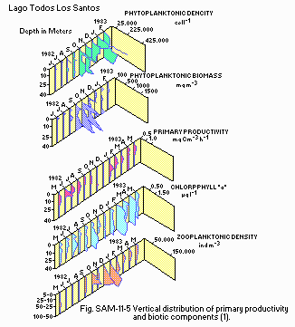
Vertical distribution of primary productivity and biotic components (1).
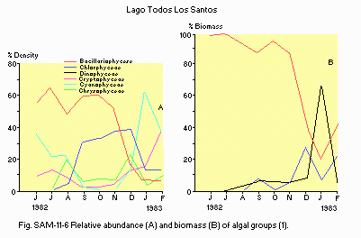
Relative abundance (A) and biomass (B) of algal groups (1).
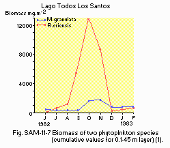
Biomass of two phytoplankton species (cumulative values for 0.1 45 m layer) (1).
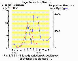
Monthly variation of zooplankton abundance and biomass (1).
G. SOCIO-ECONOMIC CONDITIONS
G2 INDUSTRIES IN THE CATCHMENT AREA AND THE LAKE- Secondary and tertiary industries: None.
- Numbers of domestic animals in the catchment area: Negligible.
H. LAKE UTILIZATION
H1 LAKE UTILIZATION- Source of water, fisheries, tourism, recreation (sport-fishing) and navigation.
I. DETERIORATION OF LAKE ENVIRONMENTS AND HAZARDS
- None (1, 2).
J. WASTEWATER TREATMENTS
J1 GENERATION OF POLLUTANTS IN THE CATCHMENT AREA (1, 2)-
a) Pristine lake environments.
K. IMPROVEMENT WORKS IN THE LAKE (1, 2)
- None.
L. DEVELOPMENT PLANS (1, 2)
- None.
M. LEGISLATIVE AND INSTITUTIONAL MEASURES FOR UPGRADING LAKE ENVIRONMENTS
M3 RESEARCH INSTITUTES ENGAGED IN THE LAKE ENVIRONMENT STUDIES- Instituto de Zoologia, Universidad Austral de Chile, Valdivia
- Departmento Botanica, Universidad de Concepcion, Concepcion
- Instituto de Biologia, Unitersidad Catolica de Valparaiso, Valparaiso
N. SOURCES OF DATA
- Questionnaire filled by the editors with the support of Dr. H. C. Campos, Instituto de Zoologia, Universidad Austral de Chile, Valdivia, Chile, based on the following sources.
- Campos, H., Steffen, W., Aguero, G., Parra, O. and Zuniga, Z. (1990) Arch. Hydrobiol., 117: 453 484.
- The editor's observation.
- Miller, A. (1976) The climate of Chile. "World Survey of Climatology, Volume 12, Climates of Central and South America" (ed. Schwerdtfeger, W.), pp. 113 145. Elsevier Publishing Company, Amsterdam-London-New York.
