
LAGO YPACARAI
An aerial view of the ahole lake
Photo: K.Nomura
A. LOCATION
- Cordillera and Central, Paraguay.
- 25:14-25:22S, 57:17-57:22W; 64.1 m above sea level.
B. DESCRIPTION
-
Lake Ypacarai is a shallow and swampy natural lake located some 30 km east of Asuncion, the capital of Paraguay. It has a surface area of approximately 60 km2 and a maximum depth of 3 m. The catchment basin of 833 km2 is largely covered by pastures and crop fields.
There are some 20 inflowing tributaries of various sizes, while only one river, Rio Slado, drains the lake joining the Paraguay River at about 20 km downstream. An extensive area of wetlands with luxuriant growth of emergent and submerged plants develops near the lake's outlet and maintains the lake water level effectively within a narrow range of fluctuation.
Since natural water bodies are particularly valuable for this flat inland country, Lake Ypacarai district offers one of the best sites for tourism and outdoor recreation in Paraguay, with abundant facilities for visitors and summer houses around the lake. The lake water is also used for drinking water supply and irrigation.
The lake has recently suffered from progressive eutrophication owing to the nutrient discharge from surrounding crop fields, livestock farms, residential areas, deforested lands and large-scale land development. An international multi-disciplinary research project has been launched since 1987 by the national government to cope with this problem (Q, 1).
C. PHYSICAL DIMENSIONS (Q)
Surface area [km2] 60 Volume [km3] 0.115 Maximum depth [m] 3.0 Mean depth [m] 2.0 Water level Unregulated Normal range of annual water level fluctuation [m] 0.2 Length of shoreline [km] ca. 40 Residence time [yr] 0.2* Catchment area [km2] 833 * 81 days.D. PHYSIOGRAPHIC FEATURES
D1 GEOGRAPHICAL- Bathymetric map: Fig. SAM-08-01.
- Names of main islands: None.
- Number of outflowing rivers and channels (name): 1 (Rio Slado).
- Climatic data at Asuncion
| Jan | Feb | Mar | Apr | May | Jun | Jul | Aug | Sep | Oct | Nov | Dec | Ann. | |
|---|---|---|---|---|---|---|---|---|---|---|---|---|---|
| Mean temp. [deg C]*1 | 27.6 | 27.1 | 25.8 | 22.9 | 20.3 | 18.0 | 18.4 | 18.7 | 20.7 | 23.5 | 25.2 | 26.8 | 22.9 |
| Precipitation [mm]*2 | 161 | 146 | 143 | 159 | 118 | 74 | 47 | 54 | 82 | 125 | 146 | 141 | 1,396 |
- Number of hours of bright sunshine: 2,530 hr yr-1.
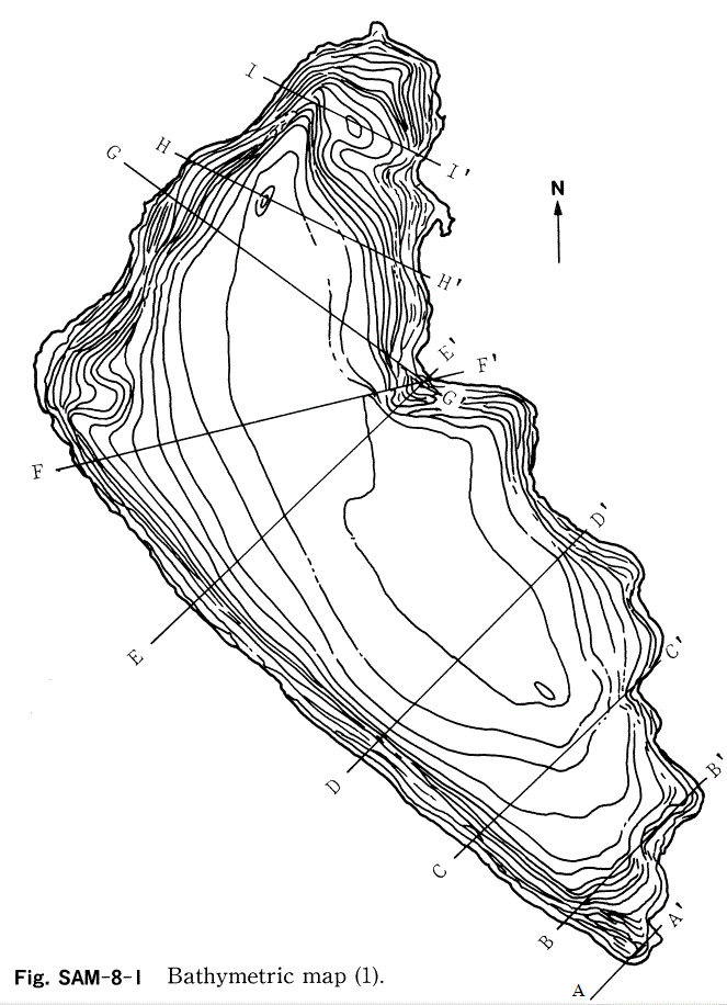
Bathymetric map (1).
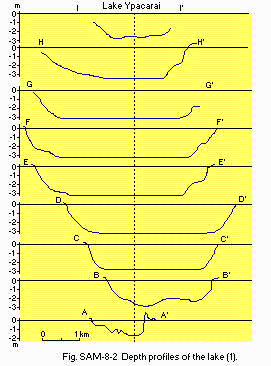
Depth profiles of the lake (1).
- Water temperature [deg C]
| Depth [m] | Mar | Apr | May | Jun | Jul | Aug |
|---|---|---|---|---|---|---|
| S* | 28.4 | 23.7 | 19.4 | 16.1 | 15.5 | 18.5 |
- Mixing type: Monomictic. Occasionally polymictic.
E. LAKE WATER QUALITY (2)
E1 TRANSPARENCY [m]| Lake centre, February-September 1984 | |||||||||||
| Jan | Feb | Mar | Apr | May | Jun | Jul | Aug | Sep | Oct | Nov | Dec |
|---|---|---|---|---|---|---|---|---|---|---|---|
| - | 0.08 | 0.08 | 0.15 | 0.07 | 0.07 | 0.08 | 0.06 | 0.15 | - | - | - |
| Lake centre, February-August 1984 | ||||||||||||
| Depth [m] | Jan | Feb | Mar | Apr | May | Jun | Jul | Aug | Sep | Oct | Nov | Dec |
|---|---|---|---|---|---|---|---|---|---|---|---|---|
| S* | - | 8.7 | 7.3 | 6.8 | 7.0 | 7.1 | 7.4 | 6.0 | 6.8 | - | - | - |
| Lake centre, February-August 1984 | ||||||||||||
| Depth [m] | Jan | Feb | Mar | Apr | May | Jun | Jul | Aug | Sep | Oct | Nov | Dec |
|---|---|---|---|---|---|---|---|---|---|---|---|---|
| S* | - | - | 74.4 | - | - | 77.0 | 33.1 | 69.1 | - | - | - | - |
| Lake centre, February-August 1984 | ||||||||||||
| Depth [m] | Jan | Feb | Mar | Apr | May | Jun | Jul | Aug | Sep | Oct | Nov | Dec |
|---|---|---|---|---|---|---|---|---|---|---|---|---|
| S* | - | 6.0 | 7.5 | 7.5 | 6.8 | 8.4 | - | 8.9 | 8.6 | - | - | - |
-
Determined by K2Cr2O7 method.
| Lake centre, February-August 1984 | ||||||||||||
| Depth [m] | Jan | Feb | Mar | Apr | May | Jun | Jul | Aug | Sep | Oct | Nov | Dec |
|---|---|---|---|---|---|---|---|---|---|---|---|---|
| S* | - | 10.3 | 12.7 | 12.3 | 12.4 | 15.7 | 12.0 | 15.5 | - | - | - | - |
- Total-N [mg l-1]
| Lake centre, February-August 1984 | ||||||||||||
| Depth [m] | Jan | Feb | Mar | Apr | May | Jun | Jul | Aug | Sep | Oct | Nov | Dec |
|---|---|---|---|---|---|---|---|---|---|---|---|---|
| S* | - | NSD | 0.582 | 0.653 | 0.724 | 0.888 | 0.702 | 0.654 | - | - | - | - |
- Total-P [mg l-1]
| Lake centre, February-August 1984 | ||||||||||||
| Depth [m] | Jan | Feb | Mar | Apr | May | Jun | Jul | Aug | Sep | Oct | Nov | Dec |
|---|---|---|---|---|---|---|---|---|---|---|---|---|
| S* | - | 0.230 | 0.273 | 0.148 | 0.295 | 0.276 | 0.259 | 0.268 | - | - | - | - |
F. BIOLOGICAL FEATURES (Q)
F1 FLORA- Emerged macrophytes
Typha sp., Scirpus sp., Pontenderia rotundifolia, Philodendron undulatum. - Floating macrophytes
Hydrocleys nymphoides, Hydromystria sp., Nymphoides sp. - Submerged macrophytes: Cabomba sp.
- Phytoplankton
Anabaena spiroides, Oscillatoria tenuis, Phormidium tenue, Melosira granulata, M. granulata f. spiralis, M. granulata var., Ankistrodesmus falcatus.
- Zooplankton
Keratell valga, K. americana, K. cochlearis, Daphnia sp., Bosmina longirostris, Bosmina sp., Diaptomus sp. - Benthos
Hirudinea sp., Hexagenia sp., Dero cooperi, Ablabesmyia sp., Micropsectra sp., Microtendipes sp., Paratendipes sp., Polypedilum sp., Procladius sp., Pseudochironomus sp., Pheotanytarsus (?) sp., Tanypus sp.
G. SOCIO-ECONOMIC CONDITIONS (Q)
G1 LAND USE IN THE CATCHMENT AREA| 1988 | ||
| Area [km2] | [%] | |
|---|---|---|
| Natural landscape | ||
| - Woody vegetation | 117.7 | 14.1 |
| - Herbaceous vegetation | 35.3 | 4.3 |
| - Swamp | 2.2 | 0.3 |
| Agricultural land | ||
| - Crop field | 240.5 | 28.9 |
| - Pasture land | 302.0 | 36.2 |
| Residential area | 135.2 | 16.2 |
| Total | 833.0 | 100 |
- Main kinds of crops: Cotton, cassava, sugar cane, vegetables.
- Levels of fertilizer application on crop fields: Light.
- Trends of change in land use in recent years
Deforestation, cultivation and urbanization have rapidly proceeded in the western part of the catchment area.
| No.of persons engaged | No. of establishments | Main products or major industries | |
|---|---|---|---|
| Primary industry | |||
| - Crop production | 3,000 | 4 | |
| - Animal husbandry | 50 | 4 | |
| Secondary industry | - | - | Vegetable oil refinery, butchery, sausage, noodle, juice |
- Number of domestic animals in the catchment area
Cattle 61,100, sheep 1,800, swine 14,600, horses, goat, donkey and mule.
| 1982 | |||
| Population | Population density [km-2] | Major cities | |
|---|---|---|---|
| Total | 207,326 | 249 | Aregua, Capiata, Itaugua, Lugue, San Lovenzo, Ypacarai, San Bernardino, Pirayu |
H. LAKE UTILIZATION (Q)
H1 LAKE UTILIZATION- Source of water, sightseeing and tourism and recreation (swimming and yachting).
| 1987 | |
| Use rate [m3 day-1] | |
|---|---|
| Domestic | 700 (winter) |
| 2,000 (summer) | |
I. DETERIORATION OF LAKE ENVIRONMENTS AND HAZARDS (Q)
I1 ENHANCED SILTATION- Extent of damage: Serious.
- Supplementary notes
Lake water is always turbid with suspended silt and clay derived from roads and cultivated lands. Therefore, purification process for potable water takes time.
- Present status: Detected but no minute data.
- Main contaminants
1988 Name of Concentration [ppm] in contaminant Water T-Fe 0.38 T-Mn 0.017
- Environmental quality standards for contamination in the lake
Under consideration.
- Nuisance caused by eutrophication
Unusual algal bloom (Anabaena, Microcystis). - Nitrogen and phosphorus loadings to the lake [kg day-1]
1988 Sources Industrial & Domestic Agricultural Total T-N 652 1,426 2,078 T-P 120 712 832
- Supplementary notes
Trends of eutrophication in recent years are not clarified due to the lack of monitoring of water quality in the lake and rivers, though monthly observations of certain water quality items were made in 1982 and 1984. Countermeasures for water quality degradation are still under consideration.
J. WASTEWATER TREATMENTS
J1 GENERATION OF POLLUTANTS IN THE CATCHMENT AREA-
e) Severe pollution with little wastewater treatment.
| Point source [%] | Non-point source [kg yr-1] | ||
|---|---|---|---|
| Domestic | Industrial | Domestic animal and siltation | |
| COD | 52 | 44 | 9,800,000 |
| T-N | 78 | 15 | 370,000 |
| T-P | 65 | 30 | 94,000 |
| SS | - | - | 20,000,000 |
- Percentage of municipal population in the catchment area provided with
adequate sanitary facilities (on-site treatment systems) or public sewerage: 98.6%. - Percentage of rural population with adequate sanitary facilities (on-site
treatment systems): 97.4%. - Municipal wastewater treatment systems
No. of tertiary treatment systems: 0. No. of secondary treatment systems: 0. No. of primary treatment systems: 1. No. of other types: 0. - Industrial wastewater treatment systems
No. of industrial wastewater treatment systems: 2-4 (oxidation pond).
K. IMPROVEMENT WORKS IN THE LAKE (Q)
None.L. DEVELOPMENT PLANS (Q)
Under consideration.M. LEGISLATIVE AND INSTITUTIONAL MEASURES FOR UPGRADING LAKE ENVIRONMENTS (Q)
M1 NATIONAL AND LOCAL LAWS CONCERNED- Names of the laws (the year of legislation)
- Sanitation Act (Law No. 836)(1980)
- Presidential Ordinance No. 18831 (1986)
- Responsible authorities
- Ministry of Public Health and Social Welfare
- Main items of control: Not yet decided.
- National Environmental Sanitation Service, Asuncion
- National Institute for Technology and Standards, Asuncion
- Institute of Basic Science, Asuncion National University
N. SOURCES OF DATA
- Questionnaire filled by Mr. K. Nomura, Shiga Prefectural Institute of Public Health and Environmental Science, Otsu, Japan.
- Nomura, K. Personal communication.
- After Estudio Limnologico del Lago Ypacarai by ICB, Univ. Nac. Asuncion.
- Nakajima, K. (1990) The study on water pollution control plan for the Lake Ypacarai and its basin. Water Pollution Research (Suishitsu Odaku Kenkyu), 13(7): 20-23 (in Japanese).
