
LAGO TITICACA (LAKE TITICACA)
An inlet of Lago Pequeno with totora stands and totora boats
Photo: T.Kira
A. LOCATION
- Puno, Peru; and La Paz, Bolivia.
- 14:07-17:08S, 68:02-71:06W; 3,812 m above sea level.
B. DESCRIPTION
-
Lake Titicaca is the largest freshwater lake in South America, located on the border between Peru and Bolivia between the two snowy mountain ranges of East and West Cordillera in the central Andes. The lake is 8,372 km2 wide, including both the deep main basin (Lago Mayor) and the shallow sub-basin (Lago Pequeno), and its altitude (3,812 m) is unrivalled among large lakes of this size class in the world.
The distribution of old coastal terraces indicates that a huge body of water reaching as far south as the Uyuni Depression once existed during an inter- glacial period of the Pleistocene, but the lake's size has been greatly reduced due to the increasing aridity of climate and the formation of an effluent stream. The water of Titicaca is now drained via the Rio Desaguadero into Lago Poopo, which, however, has no outlet to the sea.
The whole catchment area on the high plateau of Altiplano remains almost treeless, and is covered by coarse grasses with scattered fields of potato, barley, quinoa (Chenopodium quinoa) and the other local crops. The lake is fringed by a swampy zone of totora (Scirpus tatora), which is indispensable for the life of inhabitants on the shore, furnishing materials for the famous reed-boats and floating gardens where they grow potatoes.
The line between Puno (Peru) at the northwestern end of the lake and Guaqui (Bolivia) on the southwestern shore is an important shipping route for Bolivia. an inland country without seaside territory. Recent development of cities with manufacturing industry and a few sightseeing sites are going to affect the quality of the lake water to a certain extent.
C. PHYSICAL DIMENSIONS (Q, 3)
| Surface area [km2] | 8,372 |
| Volume [km3] | 893 |
| Maximum depth [m] | 281 |
| Mean depth [m] | 107 |
| Water level | Unregulated |
| Length of shoreline [km] | 1,125 |
| Residence time [yr] | 1,343 |
| Catchment area [km2] | 58,000 |
D. PHYSIOGRAPHIC FEATURES
D1 GEOGRAPHICAL- Sketch map: Fig. SAM-04-0l.
- Number of outflowing rivers and channels (name): 1 (Desaguadero R.).
- Climatic data at Puno, 1973 (Q)
| Jan | Feb | Mar | Apr | May | Jun | Jul | Aug | Sep | Oct | Nov | Dec | Ann. | |
|---|---|---|---|---|---|---|---|---|---|---|---|---|---|
| Mean temp. [deg C] | 10.7 | 10.7 | 10.3 | 9.5 | 8.0 | 6.2 | 5.7 | 7.4 | 8.3 | 10.4 | 10.7 | 10.3 | 9.0 |
| Precipitation [mm] | 238 | 132 | 159 | 98 | 13 | 0 | 2 | 6 | 33 | 16 | 30 | 71 | 797 |
- Number of hours of bright sunshine: 3,034 hr yr-1.
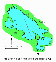
Sketch map of the lake (Q).
- Water temperature: Fig. SAM-04-02.
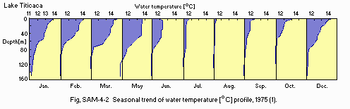
Seasonal trend of water temperature [deg C] profile, 1975 (1).
- Mixing type: Monomictic.
- Notes on water mixing and thermocline formation
Thermal profiles in the lake show a thick epilimnion with relatively little difference between epilimnetic (16deg C max.) and hypolimnetic (11.ldeg C) temperatures. There is a period of almost complete overturn in the dry season from July to September.
E. LAKE WATER QUALITY
E1 TRANSPARENCY [m](Q)| 1973 | ||||||||||||
| Jan | Feb | Mar | Apr | May | Jun | Jul | Aug | Sep | Oct | Nov | Dec | |
|---|---|---|---|---|---|---|---|---|---|---|---|---|
| 5.3 | 4.5 | 5.8 | 6.5 | 7.0 | 8.5 | 10.0 | 10.5 | 8.7 | 9.3 | 6.2 | 6.0 | |
- Surface water: 8.6.
- 780.
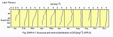
Seasonal and vertical distribution of DO [mg l-1], 1975 (1).
E7 NITROGEN CONCENTRATION (2)
- NO3-N [mg l-1]
| 1973 | ||||||||||||
| Depth [m] | Jan | Feb | Mar | Apr | May | Jun | Jul | Aug | Sep | Oct | Nov | Dec |
|---|---|---|---|---|---|---|---|---|---|---|---|---|
| 0-30 | .060 | .060 | .065 | .110 | .120 | .165 | .240 | .130 | .105 | .070 | .115 | .105 |
| >30 | .060 | .085 | .095 | .190 | .190 | .130 | .240 | .120 | .105 | .060 | .125 | .120 |
- PO4-P [mg l-1]
| 1973 | ||||||||||||
| Depth [m] | Jan | Feb | Mar | Apr | May | Jun | Jul | Aug | Sep | Oct | Nov | Dec |
|---|---|---|---|---|---|---|---|---|---|---|---|---|
| 0-30 | .023 | .016 | .017 | .013 | .013 | .016 | .020 | - | .023 | .016 | .009 | .007 |
| >30 | .065 | .038 | .049 | .029 | .044 | .046 | .027 | - | .039 | .028 | .016 | .025 |
F. BIOLOGICAL FEATURES
F1 FLORA (Q)- Emerged macrophytes: Scrirpus tatora, Hydrocotyle sp., Lilaeopsis sp.
- Floating macrophytes: Lemna sp., Azolla sp.
- Submerged macrophytes
Myriophyllum elatinoides, Chara sp., Elodea potamogeton, Nitella clavata, Potamogeton strictus, Ruppia filifolia. - Phytoplankton
Lyngbya vacuolifera, Anabaena sphaerica, Nodularia harveyaba, Ulothrix subtilissima, Oocystis borgei, Ankistrodesmus falcatus, Selenastrum minutum, Cyclotella stelligera.
- Zooplankton (Q)
Copepoda (Boeckella titicacae, Microcyclops leptopus), Cladocera (Bosmina hagmanni), Rotifera (Asplanchna sp.). - Benthos: Taphius spp., Littoridina spp. (3).
- Fish (Q)
Orestias agassii, O. luteus, O. pentlandii, Trichomycterus rivulatus, Salmo gairdnerii, Basilichthys bonariensis.
| Jan | Feb | Mar | Apr | May | Jun | Jul | Aug | Sep | Oct | Nov | Dec | Ann. |
|---|---|---|---|---|---|---|---|---|---|---|---|---|
| 1.35 | 1.11 | 1.25 | 1.17 | 1.47 | 1.64 | 1.48 | 2.01 | 1.20 | 0.74 | 1.28 | 2.79 | 1.46 |
- Phytoplankton [mg C m-3]
| 1973 | ||||||||||||
| Jan | Feb | Mar | Apr | May | Jun | Jul | Aug | Sep | Oct | Nov | Dec | Ann. |
|---|---|---|---|---|---|---|---|---|---|---|---|---|
| 17.4 | 58.5 | 29.4 | 23.5 | 30.9 | 30.9 | 28.1 | 29.3 | 16.7 | 13.5 | 13.2 | 28.0 | 26.8 |
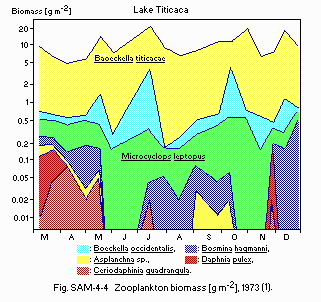
Zooplankton biomass [g m-2], 1973 (1).
F5 FISHERY PRODUCTS
- Annual fish catch [metric tons]
1980: 6,327.
G. SOCIO-ECONOMIC CONDITIONS (Pero only)
G1 LAND USE IN THE CATCHMENT AREA| 1983 | ||
| Area [km2] | [%] | |
|---|---|---|
| Natural landscape | ||
| - Woody vegetation | 25 | 0.0 |
| - Herbaceous vegetation | 36,375 | 74.8 |
| - Swamp | 210 | 0.4 |
| - Others | 4,120 | 8.5 |
| Agricultural land | 2,500 | 5.2 |
| Residential area | 10 | 0.0 |
| Others | 5,380 | 11.1 |
| Total | 48,620 | 100.0 |
- Main types of woody vegetation: Budelia ccolli, Polylepis incana.
- Main types of herbaceous vegetation
Festuca dolichopylla, Muhlenbergia fastigiata, Carex sp., Calamagrostis heterophylla, C. curvila. - Main species of swamp vegetation: Juncus sp., Scirpus sp.
- Main kinds of crops: Barley, potato and quinoa.
| 1981 | |||
| Gross product during the year [mill. Soles] | No.of persons engaged | No of establishments | |
|---|---|---|---|
| Primary industry | |||
| - Agriculture* | 1,809 | 3,200 | 31 |
| - Fisheries | 21 | 180 | 9 |
| Secondary industry | |||
| - Manufacturing | 1,027 | 869 | 22 |
| - Mining | 425 | 231 | 10 |
| Tertiary industry | N.A. | 425 | 37 |
| 1981 | |||
| Population | Population density [km-2] | Major cities (population) | |
|---|---|---|---|
| Total | 890,300 | 12.3 | Juliaca (200,000), Puno Ilave, Ayaviri. |
H.LAKE UTILIZATION
H1 LAKE UTILIZATION (Q)- Source of water, fisheries, navigation, tourism and recreation (sport- fishing).
| 1982 | |
| Use rate [m3 sec-1] | |
|---|---|
| Domestic | 0.40 |
| Irrigation | 0.25 |
| Industrial | 0.004 |
| Power plant | 0.40 |
| Others | |
| - Breeding | 0.29 |
| - Mining | 0.03 |
J. WASTEWATER TREATMENTS (Peru only)
J1 GENERATION OF POLLUTANTS IN THE CATCHMENT AREA-
f) Limited pollution without wastewater treatment.
- Municipal sewerage system: Not present.
M. LEGISLATIVE AND INSTITUTIONAL MEASURES FOR UPGRADING LAKE ENVIRONMENTS
M1 NATIONAL AND LOCAL LAWS CONCERNED (Peru)(Q)- Names of the laws (the year of legislation)
- Water Code (Law No. 17752)(1969)
- Responsible authorities
- Ministry of Health (water quality) and Ministry of Agriculture (water managements)
N. SOURCES OF DATA
- Questionnaire filled by Dr. Jose Vera Rivas Plata, the Peruvian Sea Institute, Callao.
- Hanek, G. (ed.)(1982) La Pesqueria en el Lago Titicaca (Peru), Presente y Futuro. Proyecto FAO-PER/76/022.
- Richerson, P., Widmer, C. & Kittel, T. (1977) The Limnology of Lake Titicaca (Peru-Bolivia), a Large High Altitude Tropical Lake. 79 pp. Univ. Calif. Davis.
- Serruya, C. & Pollingher, U. (1983) Lakes of the Warm Belt. 569 pp. Cambridge University Press, London.
