
EZEQUIEL RAMOS MEXIA RESERVOIR
A view from the lakeside
Photo: A.Mariazzi
A. LOCATION
- Rio Negro Province, Argentina.
- 39:50S, 66:20W; 381 m above sea level.
B. DESCRIPTION (Q)
-
Ezequiel Ramos Mexia Reservoir is a man-made lake in the Southern Andean Range, about 600 km away from Bahia Blanca. The lake was formed in 1972 by the damming of Limay River, which flows out from Lake Nahuel Huapi. The Limay Valley is formed by the 10-30 m thick layer of well-graded pebbles mixed with 30% of sand. The stratigraphic structure of the lake district consists of three kinds of sediments; a) Cretaceous sediments emerging continuously on both sides of the reservoir, b) Cenozoic sediments of conglomerates of variable sandy and clayey matrix, and c) recent sediments of fine to very fine sands forming dunes up to 7 m high on the northeastern side of the reservoir.
The lake water is soft, neutral to slightly alkaline, basically bicarbonate- calcic. The chlorophyll concentration and primary production are relatively low because of the low concentrations of nutrients (inorganic nitrogen and total phosphorus) and the short residence time. Therefore, the reservoir may be classified as an oligo-mesotrophic lake.
C. PHYSICAL DIMENSIONS (Q)
| Surface area [km2] | 816 |
| Volume [km3] | 20.2 |
| Maximum depth [m] | 60 |
| Mean depth [m] | 24.7 |
| Water level | Regulated |
| Length of shoreline [km] | 346 |
| Residence time [yr] | 1 |
| Catchment area [km2] | 24,420 |
D. PHYSIOGRAPHIC FEATURES (Q)
D1 GEOGRAPHICAL- Sketch map: Fig. SAM-03-0l.
- Names of main islands: None.
- Number of outflowing rivers and channels (name): 1 (R. Negro).
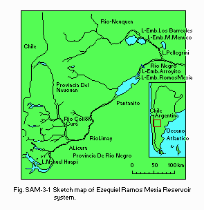
Sketch map of the lake system.
D2 CLIMATIC
- Water temperature: Fig. SAM-03-02.
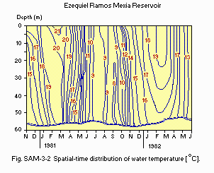
Spatial-time distribution of water temperature [deg C].
- Mixing type: Monomictic.
E. LAKE WATER QUALITY (Q)
E1 TRANSPARENCY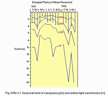
Seasonal trend of transparency [m] and relative light transmission [%].
E3 SS [mg l-1]
-
57.8 (52.1-69.5).
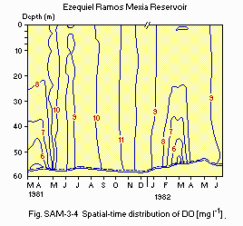
Spatial-time distribution of DO [mg l-1].
E6 CHLOROPHYLL CONCENTRATION
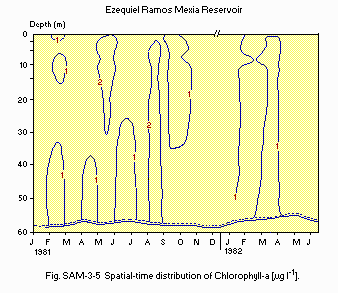
Spatial-time distribution of Chlorophyll a [micro g l-1].
E7 NITROGEN CONCENTRATION
- NH4-N [micro g l-1]: 10.
- NO3-N [micro g l-1]: 10 (10-50).
- NO2-N [micro g l-1]: 10.
- PO4-P [micro g l-1]: 5 (5-47).
- Total-P [micro g l-1]: 10 (5-53).
F. BIOLOGICAL FEATURES (Q)
F1 FLORA- Phytoplankton
Anabaena circinalis, Pandorina morum, Eudorina elegans, Binuclearia eriensis, Cyclotella stelligera, Melosira italica, M. granulata, M. granulata var. angustissima f. spiralis, Dinobryon divergens, Gymnodinium sp.
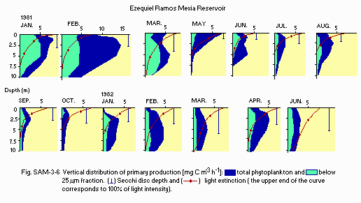
Vertical distribution of primary production [mg C m-3 h-1].
F4 BIOMASS
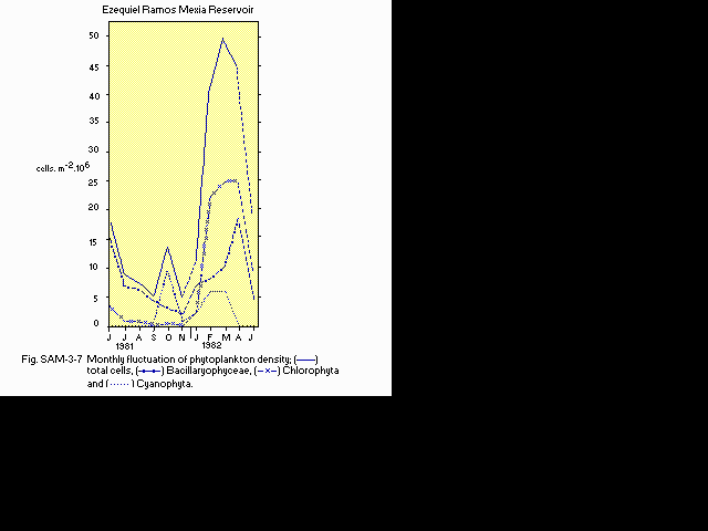
Monthly fluctuation of phytoplankton density.
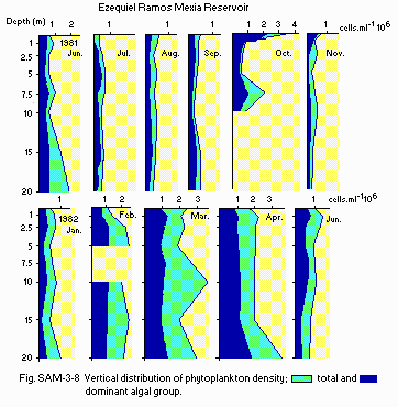
Vertical distribution of phytoplankton density.
G. SOCIO-ECONOMIC CONDITIONS
G2 INDUSTRIES IN THE CATCHMENT AREA AND THE LAKE (Q)- Secondary and tertiary industries: None.
- Number of domestic animals in the catchment area: None.
| Population | Population density [km-2] | Major cities (population) | |
|---|---|---|---|
| Rural | 2,000 | None | |
| Total | 2,000 | 0.08 | (One small village) |
H. LAKE UTILIZATION
H1 LAKE UTILIZATION (Q)- Sources of water, navigation and transportation, sightseeing and tourism, recreation (swimming and sport-fishing) and fisheries.
| 1987 | ||
| Use rate | ||
|---|---|---|
| Domestic | Negligible | |
| Irrigation | Negligible | |
| Industrial | Negligible | |
| Power plant | l,200 MW | |
I. DETERIORATION OF LAKE ENVIRONMENTS AND HAZARDS
I1 ENHANCED SILTATION (Q)- Extent of damage: Not serious.
- Present status: Not detected.
- Nuisance caused by eutrophication: None.
Mean values and ranges of annual variation of nitrogen and phosphorus concentration in affluents [micro g l-1]
| Affluent | Collon Cura River | Limay River (Alicura) | Limay River (Pantanito) | |||
|---|---|---|---|---|---|---|
| Avg. | Range | Avg. | Range | Avg. | Range | |
| PO4-P | 5 | - | 5 | - | 5 | - |
| Total P | 17 | 5-34 | 8 | 5-11 | 9 | 5-11 |
| NO3-N | 10 | - | 10 | - | 10 | - |
| NO2-N | 10 | - | 10 | - | 10 | - |
| NH4-N | 10 | - | 10 | - | 10 | - |
- Extent of damage: None.
J. WASTEWATER TREATMENTS
J1 GENERATION OF POLLUTANTS IN THE CATCHMENT AREA (Q)-
b) No sources of significant pollution.
- Wastewater treatment systems
One small-scale domestic wastewater treatment plant.
K. IMPROVEMENT WORKS IN THE LAKE (Q)
- None.
L. DEVELOPMENT PLANS (Q)
- None.
N. SOURCES OF DATA
- Questionnaire filled by Dr. A. Mariazzi, Facultad de Ciencias Naturales y Museo, Instituto de Limnologia, La Plata, Argentina.
