REPRESA DO LOBO (BROA RESERVOIR)
A bird-eye view of the whole lake

Photo: J.G.Tundisi
A. LOCATION
- Sao Paulo State, Brazil.
- 22:12S, 47:51W; 710 m above sea level.
B. DESCRIPTION
Broa Reservoir is a man-made lake at the centre of San Paulo State of Brazil created in a tropical savanna (cerrado) region in 1936 by damming up the Itaqueri River, a small tributary of the Rio Parana. At present, however, the lake is turned into an area of environmental protection because of its importance as a recreation area of scenic beauty and of scientific activities in and around the lake. Large scientific and educational projects are now in progress.
The lake is 7.5 km long and has a very flat basin with a mean water depth of 3 m. A maximum depth of 12 m is observed near the dam site. The water level fluctuates within a range of 1.5 m, being high in April at the end of rainy season and low in September at the end of dry season.
A large portion of its catchment area is covered by sandy soils. which are very aged and extremely infertile. The lake water is also oligotrophic and low in nitrogen level, and certain heavy metals often limit phytoplankton production.
Since the lake is located only 100 km apart from large reservoir systems of S. Paulo State and its water remains relatively free from eutrophication and pollution, it serves as an important standard system for comparison with the large eutrophied reservoirs. The limnology of this reservoir was opened by Brazilian scientists in 1971. Several climatological, hydrological, biological and water chemistry aspects were studied. The researches also cover the ecology, physiology and chemistry of almost all organisms present in the lake. The number of scientific papers so far published regarding this lake now amounts to approximately 200. including several masters and doctoral theses prepared at the University of S. Paulo and Federal University of S. Carlos. The Centre for Hydrological Researches and Applied Ecology, University of S. Paulo, is currently engaged in scientific projects including the modelling of Broa Reservoir system. Educational programs using the lake area as a natural laboratory have also started since 1985 (Q3, Q1, Q2).
C. PHYSICAL DIMENSIONS (1, 2)
| Surface area [km2] | 7 |
| Volume [km3] | 0.022 |
| Maximum depth [m] | 12.0 |
| Mean depth [m] | 3.0 |
| Water level | Regulated |
| Normal range of annual water level fluctuation [m] | 1.5 |
| Length of shoreline [km] | 18.3 |
| Residence time [yr] | 0.1 |
| Catchment area [km2] | 280 |
D. PHYSIOGRAPHIC FEATURES
D1 GEOGRAPHICAL (Q3)
- Bathymetric map: Fig. SAM-0l-0l and 02.
- Names of main islands: None.
- Number of outflowing rivers and channels (name)
1 (Rio do Lobo-Rio Jacare Guacu).
D2 CLIMATIC (Q3, 17, 18)
- Climatic data at Centre for Hydric Resources, University of Sao Paulo, 1971-
1986*. * Cf. Fig. SAM-01-03.
- Number of hours of bright sunshine (Sao Carlos): 2,663 hr yr-1.
- Solar radiation (Sao Carlos): 8.0 MJ m-2 day-1.
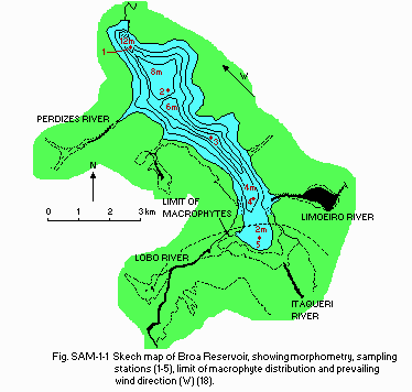
Fig. SAM-01-01
Sketch map of Broa Reservoir, showing morphometry, sampling stations (1-5), limit of macrophyte distribution and prevailing wind direction (W)(18).
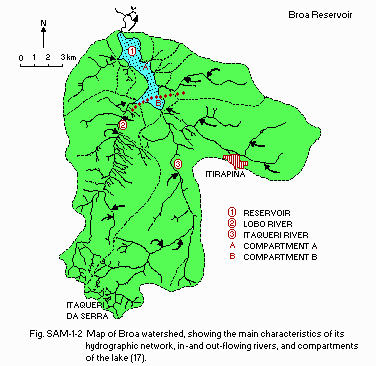
Fig. SAM-01-02
Map of Broa watershed, showing the main characteristics of its hydrographic network, in- and out-flowing rivers, and compartments of the lake (17).
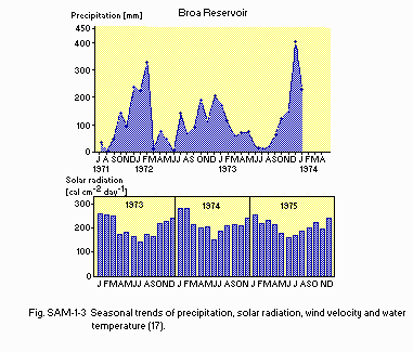
Fig. SAM-01-03
Seasonal trends of precipitation, solar radiation, wind velocity and water temperature (17).
- Water temperature [deg C](3)
Station 1, November 1974-October 1975 Depth Jan Feb Mar Apr May Jun Jul Aug Sep Oct Nov Dec
- S* 25.7 26.1 26.8 23.6 20.9 18.5 17.4 19.8 21.8 23.0 24.5 24.5 * Surface.
- Freezing period: None.
- Notes on water mixing and thermocline formation
Prevailing strong wind prevents stratification.
E. LAKE WATER QUALITY
E1 TRANSPARENCY [m](3)
| 1973-1975 |
| Depth [m] | Jan | Feb | Mar | Apr | May | Jun | Jul | Aug | Sep | Oct | Nov | Dec |
|---|
| | 1.3 | 1.7 | 2.1 | 2.1 | 2.1 | 2.0 | 1.8 | 1.9 | 1.7 | 1.5 | 1.7 | 1.6 |
E2 pH (3)
| 1973-1974 |
| Depth [m] | Jan | Feb | Mar | Apr | May | Jun | Jul | Aug | Sep | Oct | Nov | Dec |
|---|
| S* | 5.5 | 5.6 | 6.2 | - | 5.8 | 5.9 | 5.9 | 6.0 | 5.8 | 5.9 | 6.3 | 5.8 |
* Surface.
E3 SS [mg l-1](3)
| 1973-1974 |
| Depth [m] | Jan | Feb | Mar | Apr | May | Jun | Jul | Aug | Sep | Oct | Nov | Dec |
|---|
| S* | 7.9 | 5.8 | 5.1 | 7.1 | 4.8 | 5.3 | 2.4 | 5.6 | 6.5 | 8.1 | 9.4 | 4.6 |
* Surface.
E4 DO [mg l-1](3)
| 1973-1974 |
| Depth [m] | Jan | Feb | Mar | Apr | May | Jun | Jul | Aug | Sep | Oct | Nov | Dec |
|---|
| S* | 7.5 | 7.3 | 7.3 | 8.5 | 8.4 | 7.7 | 8.8 | 8.7 | 8.3 | 8.1 | 7.5 | 7.6 |
* Surface.
E6 CHLOROPHYLL CONCENTRATION [micro g l-1](4)
| 1975-1976 |
| Depth [m] | Jan | Feb | Mar | Apr | May | Jun | Jul | Aug | Sep | Oct | Nov | Dec |
|---|
| S* | 17 | 10 | 10 | 9 | 22 | 15 | 15 | 11 | 14 | 23 | 33 | 23 |
* Surface.
E7 NITROGEN CONCENTRATION (5)
- NO3-N [micro g l-1]
January-February*1: 0.6-2.6. July*2: 0.0-1.1. *1 Summer. *2 Winter.
E8 PHOSPHORUS CONCENTRATION [micro g l-1](5)
| Depth [m] | Jan-Feb*1 | Jul*2 |
|---|
| Dissolved-P | | 0.8-0.9 | 0.7-0.8 |
| Total-P | | 12-16 | 11-14 |
*1 Summer. *2 Winter.
F. BIOLOGICAL FEATURES
F1 FLORA (6, 7, 11, 12, 15, 16, 18, 19)
- Floating macrophytes: Nymphoides indicum, Pontederia cordata.
- Submerged macrophytes
Mayaca sellowiana, Utricularia inflata, U. vulgaris, Ludwigia sp., Eleocharis sp.
- Phytoplankton
Anomoeoneis serians, Cymbella pusila, C. amphicephala, Frustulia rhomboides, Melosira italica, Navicula pupula. Dominant phytoplankton during winter (July-September): Melosira italica (wind action on the bottom of the lake resuspends Melosira).
F2 FAUNA (Q, 8, 11, 12, 15, 16)
- Zooplankton
Rotifera (Ptygura, Conochiloide, Filinia, Brachionus falcatus, B. mirabilis, Keratella, Lecane, Polyarthra), Cladocera (Bosmina coregoni, Bosminopsis deitersi, Diaphanosoma sp., Argyrodiaptomus furcatus, Thermoxyclops minutus).
- Benthos: Chironomidae, Chaoborinae, Tanypodinae.
- Fish
Geophagus brasiliensis, Hoplias malabaricus*, Leporinus octofasciatus, Astyanax fasciatus*, A. bimamlatus*. * Economically important.
F3 PRIMARY PRODUCTION RATE [mg C m-2 day-1](10)
| Station 1, 1973-1976 |
| Gross production |
| Jan | Feb | Mar | Apr | May | Jun | Jul | Aug | Sep | Oct | Nov | Dec |
| 350 | 280 | 300 | 250 | 180 | 150 | 130 | 160 | 220 | 230 | 350 | 400 |
Cf. Maximum production rate of Argyrodiaptomus furcatus) in winter [mg C m-3 day-1]: 30.
F7 NOTES ON THE REMARKABLE CHANGES OF BIOTA IN THE LAKE IN RECENT YEARS (17)
No remarkable change. Occasional changes occurred due to the interaction of such hydrological processes as low water level, increase in flushing rate, etc., resulting in the shift of dominance from diatoms (e.g. Melosira italica) to flagellates (e.g. Chrysophyceae), from large-celled phytoplankton to small- celled species, and from copepods to rotifers.
G. SOCIO-ECONOMIC CONDITIONS
G1 LAND USE IN THE CATCHMENT AREA (16, Q3)
| 1986 |
| Area [km2] | [%] |
|---|
| Natural landscape |
| - Woody vegetation | 56 | 20 |
| - Herbaceous vegetation | 56 | 20 |
| - Swamp | 28 | 10 |
| - Others | 14 | 5 |
| Agricultural land |
| - Crop field | 56 | 20 |
| - Pasture land | 28 | 10 |
| Residential area | 28 | 10 |
| Others | 14 | 5 |
| Total | 280 | 100 |
- Main types of woody vegetation: Gallery forest along the river.
- Main types of herbaceous vegetation: Savanna (cerrado type).
- Types of other important vegetation: Grass swamp.
- Main kinds of crops: Maize and rice.
- Levels of fertilizer application on crop fields: Moderate.
- Trends of change in land use in recent years
Decrease of natural forest due to the progress of urbanization (recreation areas) and road construction.
G2 INDUSTRIES IN THE CATCHMENT AREA AND THE LAKE (14)
| 1986 |
| Gross product per year | No. of persons engaged | No. of establishments | Main products or major industries |
|---|
| Primary industry |
| - Crop production | N.A. | N.A. | 12 | Maize, rice |
| - Animal husbandry | N.A. | N.A. | N.A. | Cattle |
| - Others | N.A. | N.A. | N.A. | Mining (sand) |
| Secondary industry | | | None |
| Tertiary industry | | | None |
- Number of domestic animals in the catchment area: Cattle 1,000, sheep 50.
G3 POPULATION IN THE CATCHMENT AREA (14)
| 1986 |
| Population | Population density [km-2] | Major cities (population) |
|---|
| Urban | - | - |
| Rural | 27,000 | - | None |
| Total | 27,000 | 96.4 |
H. LAKE UTILIZATION
H1 LAKE UTILIZATION (14)
Tourism (no. of visitors in 1986: 150,000), recreation (swimming, sport- fishing, yachting), scientific studies and education.
H2 THE LAKE AS WATER RESOURCE (14)
| 1986 |
| Use rate |
|---|
| Domestic | Negligible |
| Irrigation | Experimental, negligible |
| Industrial | Negligible |
| Power plant | 3 [m3 sec-1] |
I. DETERI
ORATION OF LAKE ENVIRONMENTS AND HAZARDS
Il ENHANCED SILTATION (Q3)
- Extent of damage: Not serious.
- Supplementary notes
The defore
- station and mining for sand are the causes of increased siltation. Rate of sedimentation: 1 mm yr-1.
I2 TOXIC CONTAMINATION (Q3)
- Present status: Detected but not serious.
- Supplementary notes
Contamination with herbicides and pesticides was detected in the early 1980's, causing a slight increase in their accumulation in fish bodies through food chain. Countermeasures are related to the legislation of a government act to protect this area in 1983.
I3 EUTROPHICATION (Q3)
- Nuisance caused by eutrophication: None.
- Supplementary notes
No eutrophication processes were observed in the last ten years. Eutrophication is prevented by the long residence time of the lake and the growth of macrophytes in the main inflowing rivers. Measures taken to prevent eutrop
- hication include the treatment of domestic sewage and the use of septic tanks in individual residences.
I4 ACIDIFICATION (Q3)
- Extent of damage: Detected but not serious.
- Supplementary notes
- The mining operation caused only occasional, slight changes in acidity, but is expected to stop by 1987 by the legislation of the government act.
I5 OTHER HAZARDS (Q3)
Deforestation in the catchment area.
J. WASTEWAT
ER TREATMENTS
J1 GENERATION OF POLLUTANTS IN THE CATCHMENT AREA (14)
a) Pristine lake environments.
J2 APPROXIMATE PE
RCENTAGE DISTRIBUTION OF NUTRIENT LOADS (13)
| [%] |
|---|
| Non-point sources | 60 |
| Point sources |
| - Municipal | 20 |
| - Industrial | 10 |
| - Others (occasional non-point sources) | 10 |
| Total | 100 |
J3 SANITARY F
ACILITIES AND SEWERAGE (14)
-
- Percentage of municipal population in the catchment area provided with
adequate sanitary facilities (on-site treatment system) or public sewerage: 80%.
- Percentage of rural population with adequate sanitary facilities (on-site
treatment systems): 60%.
- Municipal wastewater treatment systems
- No. of tertiary treatment systems: None. No. of secondary treatment systems: None. No. of primary treatment systems: 2 (oxidation ponds). No. of other types: Septic tanks for residences.
- Industrial wastewater treatment systems
No. of industrial wastewater treatment systems: 1 (treatment tanks for mining).
K. IMPROVEMENT WORKS IN THE LAKE
K3 OTHERS (17)
Solid waste collection system and reforestation of gallery forests.
L. DEVELOPME
NT PLANS (17)

The development of recreation areas and the plantation of non-native tree species (Eucalyptus sp.) for commercial purposes have been carried out in the catchment area by private companies. The development plan of Broa area for scientific/educational purposes is also in progress under the scheme shown below.
M. LEGISLATIVE AND INSTITUTIONAL MEASURES FOR UPGRADING LAKE ENVIRONMENTS
M1 NATIONAL AND LOCAL LAWS CONCERNED (17)
- Names of the laws (the year of legislation)
- Law Declaring Broa Watershed Area of Environmental Protection (1983)
- Responsible authorities
- State Government of S. Paulo and Municipalities
- Main items of control
Road construction; deforestation; impairment of wildlife, fish fauna and gallery forest.
- Supplementary notes
Broa Catchment area has been protected since 1983 by a special law of the State Government of S. Paulo for its landscape, wildlife, scientific studies and recreational activity.
M2 INSTITUTIONAL MEASURES (17)
- Legislative measures (see above)
- Association for Protection of Broa Watershed (authorized as a public utility organization in 1984)
M3 RESEARCH INSTITUTES ENGAGED IN THE LAKE ENVIRONMENT STUDIES (Q3)
- Centre for Hydric Resources, School of Engineering, University of S. Paulo
- Institute of Physics, University of S. Paulo
- Federal University of S. Carlos
N. SOURCES OF DATA
- Questionnaire filled by Dr. N. Nakamoto, Shinshu University, Ueda, Japan. (Q1)
- Questionnaire filled by Prof. T. Sunaga, Kagawa University, Takamatsu, Japan. (Q2)
- Questionnaire filled by Prof. J. G. Tundisi, School of Engineering, University of Sao Paulo, Sao Carlos, Brazil. (Q3)
- Tundisi, J. G., Strinxino, T., Marins, M., Tundisi, T. M., Strinxino, S., Moraes, E. M. & Santos, E. P. (1972) Ecological Studies in a Lacustrine Environment. I. Progress Report. Univ. Fed. S. Carlos, Sao Carlos.
- Nakamoto, N., Marins, M. & Tundisi, J. G. (1976) Oecologia (Berl.), 23: 179-184.
- Godinho, M. J. L. (1976) Ciclo sazonal, standing stock e distribucao do bacterioplancton em ecosistema lacustre artificial, Represa do Lobo, Sao Carlos. Masters Thesis, Univ. S. Paulo.
- Rocha, 0. (1978) Flutuacan sazonal e distribucao de populacao de Diaptomuz furcatus Sars (Copepoda, Clanoida) na Represa do Lobo (Broa), Sao Carlos, S. P. Masters Thesis, Univ. S. Paulo.
- Tundisi, J. G., Tundisi, T. M., Rocha, O., Gentil, J. G. & Nakamoto, N. (1977) Sem. Medio Ambiente y Represas (Montevideo, Urguay), 1: 138-172.
- Ikusima, I., Hino. K. & Tundisi, J. G. (1983) Jap. J. Limnol., 44 (4): 304-310.
- Tundisi, J. G. & Hino, K. (1981) Rev. Brasil. Biol., 41: 63-68.
- Matsumura-Tundisi, T. & Tundisi, J. G. (1976) 0ecologia (Berl.), 25: 265- 270.
- Tundisi, J. G., Gentil, J. G. & Dirickson, M. C. (1978) Revta Brasil. Bot., 1: 35-39.
- Tundisi, J. G. (1981) Verh. Intern. Verein Limnol., 21: 1031-1039.
- Tundisi, J. G. (1986) Bol. Hidraulica e Saneamento, 11: 1-46.
- Tundisi, J. G. (in press) The Lobo (Broa) ecosystem. "Ecosystem Dynamics in Wetland and shallow Water Bodies; Proceedings of a SCOPE Meeting". Tallin, USSR.
- Tundisi, J. G. & Matsumura-Tundisi, T. (1986) Eutrophication process and trophic state for 23 reservoirs in S. Paulo State, Southern Brazil. Paper presented at the 5th Brazil-Japan Symposium on Science and Technology, Tokyo, October 1986.
- Tundisi, J. G. & Schiel, D. (1986) Sistema de Atualizacao de Professores de Ciencias e Geografia com a Utilizacao do Conceito de Bacia Hidrografica como Unidade: Conceitos Basicos, Projeto e Perspectivas. 13 pp. Publ. Especial CRHES/CDCC, IFQUSP.
- Tundisi, J. G., Matsumura-Tundisi, T., Strinxino, G., Marins, M., Mattos, M. A. & Santos, E. P. (1972) Ecological Studies at Broa Reservoir. I. Progress Report. 123 pp.
- Tundisi, J. G. & Matsumura-Tundisi, T. (1972) Ibid. II. Progress Report. 165 pp.
- Tundisi, J. G. (1986) Local community involvement in environmental planning and management-The Lobo.Broa Reservoir case study. UNCRD/ILEC/UNEP Expert Group Workshop on Environmental Planning and Management: Focus on Training Aspects Derived from Studies of Inland Water Management, Otsu and Nagoya, November 1986.
- Tundisi, J. G. (1977) Producao Primaria, "Standing stock", Fracionamento do Fitoplancton, e Factores Ecologicos em Ecosistema Lacustre Artificial. 409 pp. DSC Thesis, Univ. S. Paulo (with English summary).
- Rocha, 0. & Matsumura-Tundisi, T. (1984) Hydrobiologia, 113: 307-311.

