
LAKE TAHOE
A view from the lakeside hill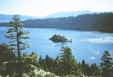
Photo: Y.Watanabe
A. LOCATION
- California and Nevada, USA.
- 39:5N, 120:3W; 1,897 m above sea level.
B. DESCRIPTION
-
Lake
Tahoe is located on the California-Nevada border in the SSierra Nevada
Mountain Range at about 1,900 m above sea level, and is surrounded by spectacular
mountain peaks. The lake water is extremely clear. The climate of the lake
basin is characterized by long but rather mild winters and short, dry summers.
The splendid scenery around the lake attracts many visitors.
The
drainage basin is comparatively small as compared with other lakes, with
the result that the residence time of lake water is very long. Tahoe soils
are derived from volcanic or granitic parent material, and are easily eroded
during heavy rain. Thus surface flows from the lake's watershed carry a
continuous load of nutrients and sediments to the lake. In addition, the
recent and rapid increase of visitors and residents has caused some eutrophication,
though the nutrient level of the lake is still quite oligotrophic. In order
to avoid further environmental disruption, the bi- state Tahoe Regional
Planning Agency was established in 1970, and has worked out a plan for
land use, transportation, conservation, recreational development and public
services. It is well known as one of the most successful environmental
management and conservation efforts in the United States.
C. PHYSICAL DIMENSIONS (1, 2, 3, 4)
| Surface area [km2] | 499 |
| Volume [km3] | 156 |
| Maximum depth [m] | 505 |
| Mean depth [m] | 313 |
| Length of shoreline [km] | 120 |
| Residence time [yr] | 700 |
| Catchment area [km2] | 841 |
D. PHYSIOGRAPHIC FEATURES
D1 GEOGRAPHICAL
- Bathymetric map: Fig. NAM-02-01.
- Number of outflowing rivers and channels (name): 1 (Truckee R.).
D2 CLIMATIC (2)
- Climatic data at Tahoe City (2)
| Jan | Feb | Mar | Apr | May | Jun | Jul | Aug | Sep | Oct | Nov | Dec | Ann. | |
|---|---|---|---|---|---|---|---|---|---|---|---|---|---|
| Mean temp. [deg C] | -2.6 | -1.9 | 0.1 | 3.3 | 7.5 | 11.4 | 15.8 | 15.4 | 11.8 | 7.2 | 2.2 | -1.1 | 5.8 |
| Precipitation [mm] | 157 | 137 | 97 | 56 | 25 | 13 | 6 | 5 | 13 | 41 | 79 | 133 | 762 |
Bathymetric map (5).

- Water temperature: Fig. NAM-02-02.
- Fig. NAM-02-02
Vertical and seasonal distribution of water temperature, the centre of the lake, April 1969-February 1970 (4).

- Freezing period: None.
- Mixing type: Monomictic.
E. LAKE WATER QUALITY
E1 TRANSPARENCY [m](1, 3)
- Surface water, 1981: 27.6.
E2 pH(1, 3)
- Surface water, 1981: 7.1-8.2.
E4 DO [mg l-1](1, 3): cf. Fig. NAM-02-03.
- Surface water, 1981: 7-11.
- DO percent saturation [%]
Surface water, 1984: 90-105.
- Fig. NAM-02-03
Vertical distribution of DO, the centre of the lake, 1969 (4).

E6 CHLOROPHYLLL CONCENTRATION [mg l-1](1, 3)
- Chlorophyll
Surface water, 1984: 0.07-0.41.
E7 NITROGEN CONCENTRATION (1, 3)
- NO3-N: Fig. NAM-02-04 and 06.
- Fig. NAM-02-04
Vertical distribution of NO3-N, the centre of the lake, July 1969-February 1970 (4).

- Total-N [micro l-1]
Surface water, 1984: 21.1.
E8 PHOSPHORUS CONCENTRATION (1, 3)
- PO4-P: Fig. NAM-02-05.
- Fig. NAM-02-05
Vertical distribution of PO4-P, the centre of the lake, July 1969-February 1970 (4).

- Total-P [micro l-1]: cf Fig. NAM-02-06.
- NO3: Fig. NAM-02-06.
Surface water, 1984: 5.8.
- Fig. NAM-02-06
Total-P and NO3, Tahoe Index Station, 1978 (6).

E10 PAST TRENDS (6)
- NO3-N [tons]
| Year | Mixing interval | Depth of mixing [m] | Euphotic zone (0-105 m) | Aphotic zone (105-450 m) |
|---|---|---|---|---|
| 1973 | 9 March-19 March | 450 | 5.71 | 14.32 |
| 1974 | 2 February-4 March | 450 | 6.20 | 14.12 |
| 1975 | 17 February-31 March | 450 | 5.81 | 13.76 |
| 1976 | 23 March-4 April | 200-250 | 4.29 | 19.94 |
| 1977 | 11 March-27 May | 175 | 3.41 | 29.34 |
| 1978 | 15 March-27 March | 125-250 | 1.87 | 25.67 |
| 1979 | 28 February-2 April | 275 | 4.64 | 24.26 |
| 1980 | 22 January-29 May | 275 | 1.6 | 12.9 |
F. BIOLOGICAL FEATURES
F1 FLORA
- Emerged macrophytes (7)
- Floating macrophytes: Nymphaea polysepala (7).
- Submerged macrophytes (7)
- Phytoplankton (4)
Typha latifolia, Carex rostrata, C. vesicaria, Glyceria borealis, G. elata .
Isoetes bolanderi, I. muricata var. hesperia, Potamogeton richardsonii, Elodea canadensis.
Melosira crenulata, Cyclotella bodanica, Navicula aurora, Fragilaria crotonensis, Asterionella formosa, Synedra ulna, Nitzschia amphibia, Staurastrum natator, Dinobryon sociale.
F2 FAUNA
- Zooplankton
- Fish: Oncorhynchus nerka, Salmo clarki (1).
Kellicottia longispina, Epischura nevadensis, Diaptomus tyrelli, Bosmina longirostris, Mysis relicta (8, 9).
F3 PRIMARY PRODUCTION RATE: Fig. NAM-02-07.
- Fig. NAM-02-07
Vertical and seasonal distribution of primary production rate, the centre of the lake, April 1969-February 1970 (4).

F4 BIOMASS: Fig. NAM-02-08.
- Fig. NAM-02-08
Seasonal change of phytoplankton biomass (nine stations in the littoral zone)(10).

F6 PAST TRENDS: Fig. NAM-02-09 and 10.
- Fig. NAM-02-09
Trend of the population of kokanee salmon (Oncorhynchus nerka)(1).

- Fig. NAM-02-10
Trend of the populations of zooplankton (6).

G. SOCIO-ECONOMIC CONDITIONS
G1 LAND USE IN THE CATCHMENT AREA (1)
- 1977
| Area[km2] | [%] | ||
|---|---|---|---|
| Natural landscape Woody vegetation | 706.4 | 88.1 | |
| Agricultural land | 10.1 | 1.3 | |
| Residential area | 64.8 | 8.1 | |
| Others | |||
| - | Commercial area | 8.7 | 1.1 |
| - | Public service | 11.9 | 1.5 |
| Total | 801.9 | 100.0 |
- Main types of woody vegetation (6)
- Main types of herbaceous vegetation (6)
Lodgepole pine plantation (Pinus contorta var. murryana); subalpine red fir forest (Abies magnifica); jeffrey pine forest (Pinus jeffreyi); mixed conifer forest; deciduous broadleaf forest (Populus tremuloides).
Meadow, sagebrush and alpine communities.
G3 POPULATION IN THE CATCHMENT AREA (l)
- 1980
| Population | Population density [km-2] | Major cities (population) | |
|---|---|---|---|
| Total | 124,300 | 93 | South Lake Tahoe (50,000) |
H. LAKE UTILIZATION
H1 LAKE UTILIZATION
- Source of water, navigation and transportation, sightseeing and tourism,
recreation and fisheries.
H2 THE LAKE AS WATER RESOURCE (1)
- 1981
| Use rate [m3 sec-1] | |
|---|---|
| Domestic | 115 |
| Irrigation | N.A. |
I. DETERIORATION OF LAKE ENVIRONMENTS AND HAZARDS
I2 TOXIC CONTAMINATION
- Present status: None.
I3 EUTROPHICATION
- Nuisance caused by eutrophication: None.
J. WASTEWATER TREATMENTS
J1 GENERATION OF POLLUTANTS IN THE CATCHMENT AREA
- c) Limited pollution with wastewater treatment.
J3 SANITARY FACILITIES AND SEWERAGE
- Municipal wastewater treatment systems
Secondary and tertiary treatment systems: by activated sludge, ammonia stripping and charcoal adsorption.
M. LEGISLATIVE AND INSTITUTIONAL MEASURES FOR UPGRADING LAKE ENVIRONMENTS
M1 NATIONAL AND LOCAL LAWS CONCERNED
- Names of the laws (the year of legislation)
- Tahoe Regional Planning Compact (1969, as amended in 1980)
- Responsible authorities
- Tahoe Regional Planning Agency and State Governments of California and Nevada
- Main items of control
- Water quality, air quality and land use
N. SOURCES OF DATA
- Tahoe Regional Planning Agency (1982) Environmental Impact Statement for the Establishment of Environmental Threshold Carrying Capacities. 140 pp. South Lake Tahoe.
- Tahoe Regional Planning Agency & Forest Service, U.S. Department of Agriculture (1971) Climate and Air Quality of the Lake Tahoe Region; A Guide for Planning. 30 pp. South Lake Tahoe.
- Tahoe Regional Planning Agency & Forest Service, U.S. Department of Agriculture (1971) Limnology and Water Quality of the Lake Tahoe Region; A Guide for Planning. 13 pp. South Lake Tahoe.
- Holm-Hansen, O., Goldman, C. R., Richards, R. & Williams, P. M. (1976) Chemical and biological characteristics of water column in Lake Tahoe. Limnol. & Oceanogr., 21 (4): 548-562.
- Loeb, S. L. & Goldman, C. R. (1979) Water and nutrient transport via groundwater from Ward Valley into Lake Tahoe. Ibid., 24 (6): 1146-1154.
- Goldman C. R. (1981) Lake Tahoe: two decades of changes in a nitrogen deficient oligotrophic lake. Verh. Internat. Verein Limnol., 21: 45-70.
- Tahoe Regional Planning Agency & Forest Service, U.S. Department of Agriculture (1971) Vegetation of the Lake Tahoe Region ; A Guide for Planning. 43 pp. South Lake Tahoe.
- Goldman, C. R., Morgan, M. D., Threlkeld, S. T. & Angeli, N. (1979) A population dynamics analysis of the cladoceran disappearance from Lake Tahoe, California-Nevada. Limnol. & Oceanogr., 24 (2): 289-297.
- Threlkeld, S. T. (1981) The recolonization of Lake Tahoe by Bosmina longirostris: evaluating the importance of reduced Mysis relicta populations. Ibid., 26(3): 433-444.
- Eloranta, P. V. & Loeb, S. L. (1984) Near-shore littoral phytoplankton communities in Lake Tahoe, California-Nevada. Verh. Internat. Verein Limnol., 22: 600-604.
